Disclosure : This site contains affiliate links to products. We may receive a commission for purchases made through these links.
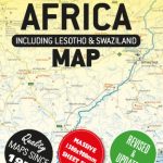
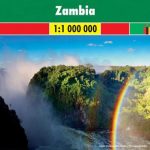
Zambia Road Map

Zambia at 1:1,500,000 from Hupe Verlag on a very clear map annotated with 413 GPS waypoints and 42 bird watching locations, plus several enlargements for most visited regions of the country annotated with GPS coordinates and street plans of Lusaka and Livingstone.The main map has altitude colouring with spot heights to show the topography, plus graphics for swamps or marshes, wetlands and areas liable to flooding. Numerous rivers are named and national parks are highlighted, with 42 important bird watching areas cross-referenced to a list of their names.Road network distinguishes between tarred and unsurfaced roads and includes seasonal tracks. Driving distances are given on main roads and locations of petrol stations, entry gates to national parks and border crossings are marked. Railway lines and ferry connections across the lakes are also included. Symbols indicate missions, campsites and various places of interest. 413 locations on the map: important road junctions, lodges and camps, natural features, etc, are cross-referenced to a list of their GPS waypoints. Latitude and longitude lines are drawn at intervals of 1ยฐ. Next to the map and on the reverse are enlargements showing the country’s most visited areas in greater detail and with further GPS waypoints, tourist accommodation plus facilities and places of interest: the Luangwa Valley with additional enlargements for the North Luangwa National Park and the Mfuwe area, the Kafue National Park with additional enlargements for the Lufupa and the Itezhi-Tezhi areas, Mosi oa Tunya National Park, and Kasanka National Park.Large panels provide street plans of central Lusaka and Livingstone, each annotated with various facilities, including selected hotels, and places of interest. Two more panels show an overview of Lusaka’s main roads, plus the Livingstone ‘“ Victoria Falls area indicating campsites. Also provided is a distance table.All the text is in English.

Related Products:
 Zambia & Eastern Africa ITMB Road Map
 Zambia InfoMap
 South Africa Giant Road Map
 Namibia Map Studio Adventure Map
 Botswana Tourist Map
 Botswana Map Studio Adventure Map
 Namibia InfoMap
 Zimbabwe National Parks Map
 Namibia Map Studio Road Atlas
Finland Karttakeskus Road Atlas
Namibia Map Studio Road Atlas
Finland Karttakeskus Road Atlas
 Latvia Jana Seta Road Atlas
 Zimbabwe Map Studio Adventure Map
 Kaokoland – North Western Namibia InfoMap
 South Africa Map Studio Road Atlas A4 PAPERBACK
Italy Hallwag Road Map
South Africa Map Studio Road Atlas A4 PAPERBACK
Italy Hallwag Road Map
 Serengeti – Photographic Checklist Map
 Czech Republic Road Atlas
 Richtersveld National Park and Northern Namaqualand
 Argentina Borch
 Zambia F&B
 Southern Norway South – Oslo – Stavanger – Bergen – Hardangervidda Cappelen Sectional Road Map
 Mozambique and Malawi
 Southern Norway North – Oslo – Bergen – Rondvassbu – Galdhopiggen Cappelen Sectional Road Map
 Dhofar Road Map – Salalah and Southern Oman
 The Kimberley – Gibb River Road Hema
 Pilbara and Coral Coast Hema Waterproof Map
 Mexico Road Map
 Mozambique Pocket Map
 Australia Hema Road & 4WD Atlas SPIRAL-BOUND
Garden Route & Route 62 Map Studio
New Zealand Kiwimaps Travellers Road Atlas
Australia Hema Road & 4WD Atlas SPIRAL-BOUND
Garden Route & Route 62 Map Studio
New Zealand Kiwimaps Travellers Road Atlas
 Zambia Reise Know-How
 Crimea Road Atlas
 Moremi Game Reserve
 Troms and Finnmark – Tromso – Hammerfest – Kirkenes Cappelen Sectional Road Map
 Australia Hema Road & 4WD Easy Read Atlas SPIRAL-BOUND
 Gotland Norstedts Road Map
 Latvia Jana Seta Compact Road Atlas
 Australia Hema Road & 4WD Atlas PAPERBACK
 Nordland and South Troms – Bronnoysund – Bodo – Narvik Cappelen Sectional Road Map