Disclosure : This site contains affiliate links to products. We may receive a commission for purchases made through these links.
Yorkshire Dales Harvey Touring & Planning Map
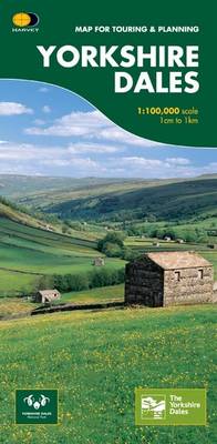
Yorkshire Dales on a road map at 1:100,000 from Harvey Map Services with several enlargements showing main roads across local towns, plus descriptions of interesting locations, advice on public transport, etc. The map shows the Dales region with altitude colouring to indicate the region’s topography. Long-distance trails such as the Dales Way, the Pennine Way, the Coast to Coast Walk or the Nidderdale Way are marked. Towns, villages and other locations are annotated with symbols to indicate what services can be found there. Surrounding the map are descriptions indicating interesting locations, notes on access by public transport, useful contact details, plus enlargements showing principal roads and facilities in Kirkby Lonsdale, Sedbergh, Hawes, Richmond, Leyburn, Pateley Bridge, Grassington, Skipton, Settle and Ingleton. Current edition of this title was published in 2014.To see the other titles in this series please click on the series link.

Related Products:
 Cycling in the Yorkshire Dales: 25 Bike Routes on Quiet Lanes in the Dales
 Yorkshire Dales for Cyclists
 Yorkshire Dales Cycle Way
 Yorkshire Dales South West Harvey Superwalker XT25
 Yorkshire Dales South West Harvey Ultramap XT40
Yorkshire Dales North West Harvey Superwalker XT25
Yorkshire Dales North West Harvey Ultramap XT40
Yorkshire Dales South West Harvey Ultramap XT40
Yorkshire Dales North West Harvey Superwalker XT25
Yorkshire Dales North West Harvey Ultramap XT40
 On Your Bike: Yorkshire Dales
 Yorkshire Dales Harvey British Mountain Map XT40
Yorkshire Dales South East Harvey Superwalker XT25
Yorkshire Dales North East Harvey Superwalker XT25
Yorkshire Dales South East Harvey Ultramap XT40
Yorkshire Dales North East Harvey Ultramap XT40
Yorkshire Dales Harvey British Mountain Map XT40
Yorkshire Dales South East Harvey Superwalker XT25
Yorkshire Dales North East Harvey Superwalker XT25
Yorkshire Dales South East Harvey Ultramap XT40
Yorkshire Dales North East Harvey Ultramap XT40
 Yorkshire Dales West
Yorkshire Dales (Slow Travel) Bradt Guide
Yorkshire Dales West
Yorkshire Dales (Slow Travel) Bradt Guide
 Yorkshire Dales North and East Walking
 Yorkshire Dales: The finest themed walks in the Yorkshire Dales National Park
 Trail and Fell Running in the Yorkshire Dales: 40 runs in the National Park, including the Three Peaks
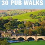 Yorkshire Dales 30 Pub Walks
 Dales Way Harvey National Trail XT40
 Walking the Dales Way: Ilkley to Bowness-on-Windermere through the Yorkshire Dales
 Dales & Valleys: The Finest Low-Level Walks in the Yorkshire Dales
 Yorkshire Dales – Outstanding Circular Walks
 Pennine Bridleway Cycling: Lancashire and the Yorkshire Dales
 Yorkshire Dales – Day Walks
 Yorkshire Dales: AA 50 Walks
 Yorkshire Dales Mountain Biking
 Yorkshire Dales South Adventure Atlas
 Yorkshire Dales Short Walks
 Yorkshire Dales Mountain Biking: Classic Pennine Trails
 Yorkshire Dales National Park Pocket Map
Yorkshire Dales: Top 10 Walks
Yorkshire Dales National Park Pocket Map
Yorkshire Dales: Top 10 Walks
 Yorkshire Dales: 40 Favourite Walks
 Yorkshire Dales – A Dog Walker`s Guide
 Walking in Cumbria`s Eden Valley: 30 walks between the Yorkshire Dales and the Solway salt marshes
 Yorkshire Dales Park Rangers Favourite Walks
 Pubs In & Around the Yorkshire Dales
 Mountain Bike Guide: The Lake District, the Howgills & the Yorkshire Dales
 Yorkshire Dales Southern & Western – Whernside, Ingleborough & Pen-y-ghent OS Explorer OL2
 Yorkshire Dales South and West