Disclosure : This site contains affiliate links to products. We may receive a commission for purchases made through these links.
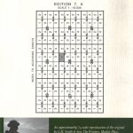
WWI Trench Map: Illies – Violaines – Festubert (part of 36C NW & 36B NE)

Illies – Violaines – Festubert (part of 36C NW and 36B NE) in a series of British Army trench maps from the WWI, reproduced by G.H. Smith & Son at approximately 7/10th of the original scales quoted against each title. The map dates from 1915 and shows the front line around Festubert held by the King`s Own Royal Lancaster Regiment. Also included are notes about Lieutenant Colonel Walter F. A. Wadham of the 1st/4th Battalion.Maps in this series show both the British and the enemy trenches. Several titles also indicate supply and ammunition dumps, machine gun and trench mortar emplacements, observation posts, etc. Most titles are annotated with a specific date when they were prepared and include on the reverse a glossary of terms used on the map. Some also include additional information on the regiments and/or individual solders connected with that particular part of the front.To see other titles in this series please click on the series link.

Related Products:
 WWI Trench Map: Wieltje – Frezenberg – Zonnebeke (ed.2)
 WWI Trench Map: Zonnebeke (28 NE 1 – ed. 9A)
WWI Trench Map: Arras (51B NW 3 – ed. 6A)
WWI Trench Map: Albert (57D SE – ed. 5E)
WWI Trench Map: Nieuport (12 SW 1 – ed. 3A)
WWI Trench Map: Wytschaete (Whitesheet: 28 SW 2 – ed. 6A)
WWI Trench Map: Vimy (44A SW 3 – ed. 11A)
WWI Trench Map: Loos (36C NW – ed. 3)
WWI Trench Map: Honnecourt (57B SW 3 – ed. 1A)
WWI Trench Map: St Julien (28 NW 2 – ed. 6A)
WWI Trench Map: Lens (36C SW 1 – ed. 9A)
WWI Trench Map: Queant (57C NE 1 – ed. 4A)
WWI Trench Map: Roclincourt (51B NW 1 – ed. 5A)
WWI Trench Map: Hebuterne (57D NE parts of 3 & 4 – ed. 2)
WWI Trench Map: Lens – Vimy (France 36C SW – ed. 9A)
WWI Trench Map: Fonquevillers (57D NE 1 & 2 – ed.2)
WWI Trench Map: Maricourt (62C NW 1 – ed. 2C)
WWI Trench Map: Zonnebeke (28 NE 1 – ed. 9A)
WWI Trench Map: Arras (51B NW 3 – ed. 6A)
WWI Trench Map: Albert (57D SE – ed. 5E)
WWI Trench Map: Nieuport (12 SW 1 – ed. 3A)
WWI Trench Map: Wytschaete (Whitesheet: 28 SW 2 – ed. 6A)
WWI Trench Map: Vimy (44A SW 3 – ed. 11A)
WWI Trench Map: Loos (36C NW – ed. 3)
WWI Trench Map: Honnecourt (57B SW 3 – ed. 1A)
WWI Trench Map: St Julien (28 NW 2 – ed. 6A)
WWI Trench Map: Lens (36C SW 1 – ed. 9A)
WWI Trench Map: Queant (57C NE 1 – ed. 4A)
WWI Trench Map: Roclincourt (51B NW 1 – ed. 5A)
WWI Trench Map: Hebuterne (57D NE parts of 3 & 4 – ed. 2)
WWI Trench Map: Lens – Vimy (France 36C SW – ed. 9A)
WWI Trench Map: Fonquevillers (57D NE 1 & 2 – ed.2)
WWI Trench Map: Maricourt (62C NW 1 – ed. 2C)
 WWI Trench Map: Ploegsteert Wood 28 SW 4 – ed. 4B)
 WWI Trench Map: Zonnebeke (28 NE 1 – ed. 7A)
WWI Trench Map: German Artillery Positions at Ervillers
WWI Trench Map: Messines (part of sheet 28)
WWI Trench Map: Zonnebeke (28 NE 1 – ed. 7A)
WWI Trench Map: German Artillery Positions at Ervillers
WWI Trench Map: Messines (part of sheet 28)
 WWI Trench Map: Bapaume (57C NW – ed. 8B)
WWI Trench Map: Meaulte (62D NE 2 – ed. 2B))
WWI Trench Map: Bapaume (57C NW – ed. 8B)
WWI Trench Map: Meaulte (62D NE 2 – ed. 2B))
 WWI Trench Map: Wytschaete (Whitesheet: 28 SW 2 – ed. 5A)
WWI Trench Map: Ovillers (57D SE 4 – ed. 2B)
WWI Trench Map: Beauquesne (57D SW – ed.2B)
Belgium/France: World War I Trench Maps of the Western Front
WWI Trench Map: Bixschoote (20 SW 4 – ed. 5A)
WWI Trench Map: Longueval (57C SW 3 – ed.2E)
WWI Trench Map: Laventie – Aubers Ridge (36 SW 1 – prov. ed.)
WWI Trench Map: Wytschaete (Whitesheet: 28 SW 2 – ed. 5A)
WWI Trench Map: Ovillers (57D SE 4 – ed. 2B)
WWI Trench Map: Beauquesne (57D SW – ed.2B)
Belgium/France: World War I Trench Maps of the Western Front
WWI Trench Map: Bixschoote (20 SW 4 – ed. 5A)
WWI Trench Map: Longueval (57C SW 3 – ed.2E)
WWI Trench Map: Laventie – Aubers Ridge (36 SW 1 – prov. ed.)
 WWI Trench Map: Thiepval Wood
 WWI Trench Map: Zillebeke (28 NW 4 & NE 3 – ed. 3E)
WWI Trench Map: St. Quentin (66C NW – ed. 3A)
WWI Trench Map: Houplines (36 NW2 & NE 1 – ed. 9A)
WWI Trench Map: Neuville-Vitasse – Bullecourt (57B SW)
WWI Trench Map: Loos (36C NW & part of 1 prov. ed.)
WWI Trench Map: Beaumont (57D SE parts of 1 & 2 – ed. 2)
WWI Trench Map: Zillebeke (28 NW 4 & NE 3 – ed. 3E)
WWI Trench Map: St. Quentin (66C NW – ed. 3A)
WWI Trench Map: Houplines (36 NW2 & NE 1 – ed. 9A)
WWI Trench Map: Neuville-Vitasse – Bullecourt (57B SW)
WWI Trench Map: Loos (36C NW & part of 1 prov. ed.)
WWI Trench Map: Beaumont (57D SE parts of 1 & 2 – ed. 2)
 WWI Trench Map: Gheluvelt (28 NE 3 – ed. 5A)
WWI Trench Map: Guillemont – Le Sars (57C SW – ed.3A)
WWI Trench Map: Beaumont (57D SE 2 – ed. 4A)
WWI Trench Map: Gheluvelt (28 NE 3 – ed. 5A)
WWI Trench Map: Guillemont – Le Sars (57C SW – ed.3A)
WWI Trench Map: Beaumont (57D SE 2 – ed. 4A)