Disclosure : This site contains affiliate links to products. We may receive a commission for purchases made through these links.
World NGS Physical / Ocean Floor Wall Map ENCAPSULATED

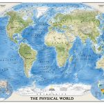
Superb representation of the ocean floor in this encapsulated version, 110x76cm/ (43″ x 30″ approx.) physical map of the world, one of the most interesting titles in the National Geographic Society’s long list of wall maps. Drawn with great skill to achieve a 3-D effect, ocean floor plains, basins, continental shelves, trenches, ridges and fractures are shown with their names, indicating in many places their depth in metres. On land masses relief shading shows the mountain chains, whilst the colouring indicates different types of terrain: arid regions, vegetation, tundra, etc. The map has names of mountain ranges, plateaux, deserts, plains, etc., but no country names or boundaries, with only selected major cities marked. The two Polar Regions are presented as insets in the top corners, while at the bottom two colourful maps of the world show the tectonic plates with the earth crust coloured according to its age, plus the world’s climatic zones. Projection is Winkel Tripel, which reduces distortion of land masses as they near the poles.* This title is also available in paper version, plus in a bigger size (175.5 x 121.5cm / 5ft 9″ x 4ft approx.) on paper or encapsulated.

Related Products:
 World NGS Physical / Ocean Floor Wall Map LARGE ENCAPSULATED
 World NGS Physical / Ocean Floor Wall Map LARGE PAPER
 World NGS Physical Wall Map POSTER-SIZE ENCAPSULATED
 World NGS Physical Wall Map POSTER-SIZE PAPER
 World NGS Decorator Wall Map ENCAPSULATED
 World NGS Decorator Wall Map LARGE ENCAPSULATED
 World NGS Explorer Executive Wall Map ENCAPSULATED
 World NGS Decorator Wall Map PAPER
 World NGS Decorator Wall Map LARGE PAPER
 NGS Executive Political World Wall Map 3-SHEET SET, ENCAPSULATED
 World NGS Executive Wall Map ENCAPSULATED
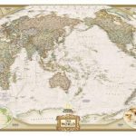
 World NGS Executive Pacific-Centered Wall Map ENCAPSULATED
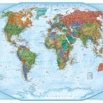
 World Global Mapping Political Wall Map MEDIUM ENCAPSULATED
 World NGS Executive Wall Map LARGE ENCAPSULATED
 World NGS Executive Pacific-Centered Wall Map LARGE ENCAPSULATED
 World Global Mapping Political Wall Map X-LARGE ENCAPSULATED
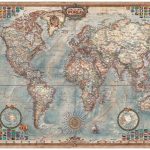 World Executive Ray & Co Wall Map ENCAPSULATED
 World: National Geographic Society Decorator Style Political Wall Maps
World Global Mapping Political Wall Map LARGE ENCAPSULATED
World: National Geographic Society Decorator Style Political Wall Maps
World Global Mapping Political Wall Map LARGE ENCAPSULATED
 Future Mapping Company Monochrome Political World Wall Map ENCAPSULATED
 World Maps International Physical Wall Map X-LARGE ENCAPSULATED
 World NGS Explorer Wall Map ENCAPSULATED
 The World – The National Geographic 125th Anniversary Wall Map ENCAPSULATED
 Future Map Company Commemorative Olympic Games World Wall Map ENCAPSULATED WITH HANGING-STRIPS
 World Hemispheres NGS Wall Map ENCAPSULATED
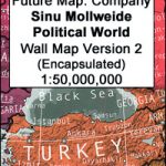 Future Mapping Co. Sinu-Mollweide Political World Wall Map V.2: blue/emerald/pink/yellow ENCAPSULATED
 World F&B Physical – Sea Relief Wall Map
 Future Mapping Co. Sinu-Mollweide Political World Wall Map V.1: gold/aqua/apple/khaki ENCAPSULATED
 World NGS Classic Wall Map 3-SHEET SET ENCAPSULATED
World Global Mapping Political Wall Map LARGE PAPER
World NGS Classic Wall Map 3-SHEET SET ENCAPSULATED
World Global Mapping Political Wall Map LARGE PAPER
 World NGS Executive Wall Map PAPER
 World NGS Classic Wall Map LARGE ENCAPSULATED
 World NGS Classic Wall Map POSTER-SIZE ENCAPSULATED
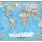
 World NGS Classic Wall Map ENCAPSULATED
 World NGS Executive Wall Map LARGE PAPER
 World Global Mapping Political Wall Map MEDIUM PAPER
 World NGS Classic Pacific-Centered Wall Map LARGE ENCAPSULATED
 World NGS Executive Pacific-Centered Wall Map PAPER
 Pacific Ocean Floor NGS Wall Map PAPER
 World NGS Executive Pacific-Centered Wall Map LARGE PAPER