Disclosure : This site contains affiliate links to products. We may receive a commission for purchases made through these links.
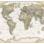
World NGS Executive Wall Map PAPER

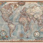
Paper version of the standard size, 116.5 x 77.5cm (46″ x 30″ approx), Atlantic centred NGS Executive political map of the world which offers current information presented in elegant antique style. Countries are in rich but muted colours and oceans in beige, with additional panels and framing in shades of brown.An unusual feature of this series is the excellent presentation of the ocean floor, with impressive relief shading to show the continental shelf around the land masses and numerous ridges, many with names. Unfortunately, although clear and very effective on all the sizes of this design, the samples presented here cannot do full justice to such fine detail.On land, the map has relief shading with names of main mountain ranges. Heights for peaks are given in feet. Within USA boundaries and names of states are shown. Four insets present the Arctic and the Antarctic, plus vegetation/land use and population density world maps. Also provided are lists of 10 largest countries by area and by populations. Projection is Winkel Tripel, which reduces distortion of land masses as they near the poles.NGS Executive Style World Maps are published in three sizes: standard (116.5 x 77.5cm / 46″ x 30″ approx), enlarged (185 x 122cm / 73″ x 48″ approx) and a 3-sheet set (296 x 193cm / 9ft 8″ x 6ft 4″ approx) – TO SEE ALL THE OPTIONS PLEASE CLICK ON THE SERIES LINK.

Related Products:
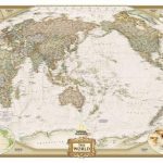
 World NGS Executive Pacific-Centered Wall Map PAPER
 World NGS Executive Wall Map LARGE PAPER
 World NGS Executive Pacific-Centered Wall Map LARGE PAPER
 World NGS Executive Mural Wall Map 3-SHEET SET PAPER
 World NGS Explorer Executive Wall Map PAPER
 NGS Executive Political World Wall Map FRAMED
 NGS Executive Political World Wall Map ENLARGED, FRAMED
 World NGS Explorer Executive Wall Map ENCAPSULATED
 World NGS Executive Wall Map ENCAPSULATED
 World NGS Executive Pacific-Centered Wall Map ENCAPSULATED
 World NGS Executive Wall Map LARGE ENCAPSULATED
 World NGS Executive Pacific-Centered Wall Map LARGE ENCAPSULATED
 World: National Geographic Society Executive Style Political Wall Maps
 NGS Executive Political World Wall Map 3-SHEET SET, ENCAPSULATED
 World NGS Executive Wall Map POSTER-SIZE PAPER
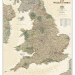 England and Wales NGS Executive Wall Map PAPER
 World NGS Decorator Wall Map PAPER
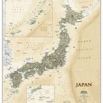 Japan NGS Executive Wall Map PAPER
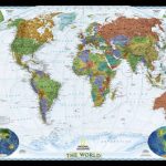
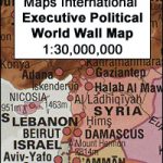 World Maps International Executive Political Wall Map
 World NGS Decorator Wall Map LARGE PAPER
 North America NGS Executive Wall Map PAPER
Mexico NGS Executive Wall Map PAPER
North America NGS Executive Wall Map PAPER
Mexico NGS Executive Wall Map PAPER
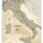 Italy NGS Executive Wall Map PAPER
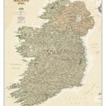 Ireland NGS Executive Wall Map PAPER
 France, Belgium and Netherlands NGS Executive Wall Map PAPER
 World NGS Classic Wall Map PAPER
 Germany NGS Executive Wall Map PAPER
 World: National Geographic Society Decorator Style Political Wall Maps
 Asia NGS Executive Wall Map PAPER
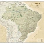 Brazil NGS Executive Wall Map PAPER
 Britain and Ireland NGS Executive Wall Map PAPER
 United States NGS Executive Wall Map PAPER
 Europe NGS Executive Wall Map PAPER
 Scotland NGS Executive Wall Map PAPER
 World NGS Classic Wall Map LARGE PAPER
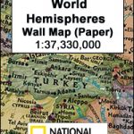 World Hemispheres NGS Wall Map PAPER
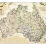 Australia NGS Executive Wall Map PAPER
 World Executive Ray & Co Wall Map ENCAPSULATED
 Europe NGS Executive Wall Map LARGE PAPER
 National Geographic World Executive Spanish – Published 2005 988 x 646 mm