Disclosure : This site contains affiliate links to products. We may receive a commission for purchases made through these links.
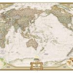
World NGS Classic Pacific-Centered Wall Map LARGE PAPER
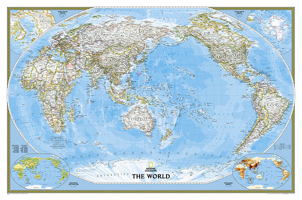
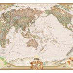
NGS Classic political map of the world, Pacific-centred enlarged size 186 x 122cm (73″ x 48″ approx) ‘“ paper version, with the publishers’ characteristic lay-out providing an attractive alternative to the more conventional world maps, countries in white but defined by different colour borders, oceans in bright blue, plus interesting additional features. All place names are in the English versions. On land subtle relief shading is added to show the topography; peak heights are given in feet. Within USA, Canada and Australia internal state/provincial borders are marked. On the oceans depth are shown in metres and arrows indicate the direction of prevailing winds as well as of hot and cold currents, many shown with names. Four insets present the Arctic and the Antarctic, plus vegetation/land use and population density. Clocks show time difference from GMT (but without the map indicating the exact geographical area covered by each time zone). The map also includes a list of 10 largest countries by area and by populations. Projection is Winkel Tripel, which reduces distortion of land masses as they near the poles.National Geographic’s ‘Classic” political maps of the world are available in different sizes and formats (paper, encapsulated or on pin board) plus Pacific-centred ‘“ TO SEE THE FULL RANGE OF TITLES IN THIS SERIES PLEASE CLICK ON THE SERIES LINK.

Related Products:
 World NGS Classic Pacific-Centered Wall Map LARGE ENCAPSULATED
 World NGS Classic Wall Map LARGE PAPER
 World NGS Executive Pacific-Centered Wall Map LARGE PAPER
 World NGS Executive Pacific-Centered Wall Map PAPER
 World NGS Classic Wall Map PAPER
 World NGS Classic Wall Map POSTER-SIZE PAPER
 World NGS Classic Mural Wall Map 3-SHEET SET PAPER
 World NGS Executive Pacific-Centered Wall Map LARGE ENCAPSULATED
 World NGS Classic Wall Map LARGE ENCAPSULATED
 NGS Classic Political World Wall Map ENLARGED, PIN BOARD, FRAMED
 World NGS Classic Wall Map STANDARD SIZE, PIN BOARD, FRAMED
 World NGS Classic Wall Map ENCAPSULATED
 World NGS Classic Wall Map 3-SHEET SET ENCAPSULATED
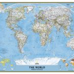
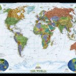
 World: National Geographic Society Classic Style Political Wall Maps
 World NGS Classic Wall Map POSTER-SIZE ENCAPSULATED
 World NGS Executive Pacific-Centered Wall Map ENCAPSULATED
 World Global Mapping Political Wall Map LARGE PAPER
 World Maps International Political Wall Map LARGE PAPER
 World NGS Decorator Wall Map LARGE PAPER
 World Rand McNally Classic Wall Map PAPER
 World NGS Executive Wall Map LARGE PAPER
 World Maps International Political Wall Map X-LARGE PAPER
 MapSherpa POD World Classic Pacific Centered
 Stanford`s Pacific-centred World Map (1884) – A3 Wall Map, Paper
Stanford`s Pacific-centred World Map (1884) – A2 Wall Map, Paper
Stanford`s Pacific-centred World Map (1884) – A1 Wall Map, Paper
Stanford`s Pacific-centred World Map (1884) – A3 Wall Map, Paper
Stanford`s Pacific-centred World Map (1884) – A2 Wall Map, Paper
Stanford`s Pacific-centred World Map (1884) – A1 Wall Map, Paper
 World Maps International Political UPSIDE-DOWN Wall Map LARGE PAPER
 World NGS Decorator Wall Map PAPER
 World Maps International Political Wall Map SMALL PAPER
 World Maps International Political Wall Map MEDIUM PAPER
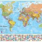
 World Maps International Political Wall Map LARGE PIN-BOARD FRAMED with flags
 World Maps International Physical Wall Map LARGE PAPER
 World Maps International Physical Wall Map X-LARGE PAPER
 Africa NGS Classic Wall Map LARGE PAPER
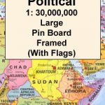
 World Maps International Political Wall Map X-LARGE PIN-BOARD FRAMED
World Global Mapping Political Wall Map MEDIUM PAPER
World Maps International Political Wall Map X-LARGE PIN-BOARD FRAMED
World Global Mapping Political Wall Map MEDIUM PAPER
 World Maps International Political Wall Map LARGE MAGNETIC-BOARD FRAMED with flags
 World Maps International Political Wall Map LARGE HANGING-STRIPS (with flags)
 MapSherpa POD World Executive Pacific Centered 1166 x 773 mm
Stanford`s Pacific-centred World Map (1884) – Original Size Wall Map, Paper
MapSherpa POD World Executive Pacific Centered 1166 x 773 mm
Stanford`s Pacific-centred World Map (1884) – Original Size Wall Map, Paper