Disclosure : This site contains affiliate links to products. We may receive a commission for purchases made through these links.
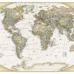
World Maps International Antique Political Wall Map
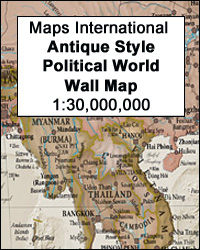
Political wall map of the world from Maps International, size 136 x 84cm (53.5″ x 33″ approx), in an antique-style presentation: countries in hues of brown, beige and tan with their borders outlined in a stronger colour – oceans in light grey, with graphic relief for the ocean floor and names in italics adding to the overall elegant, old-fashioned feel.Names of countries, cities, etc. are in their English versions. In USA, Canada, Brazil and Australia the map also shows names and boundaries of states/provinces. On land masses relief shading shows the main mountain ranges, with names and heights of selected peaks. Town symbols indicate the size of their population. The map also shows the network of main road connections. Colouring and graphic relief provides a very attractive picture of the ocean floor. The map has latitude and longitude lines at intervals of 15ยบ. Projection is Van der Grinten, with the scale at the Equator of 1:30,000,000.

Related Products:
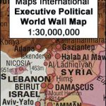 World Maps International Executive Political Wall Map
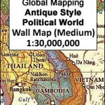
 World: Global Mapping Antique Style Political Wall Maps
 World: Global Mapping Political Wall Maps
 World Global Mapping Antique Political Wall Map LARGE PAPER
 World: Freytag & Berndt Political/Physical World Wall Maps
 World: National Geographic Society Executive Style Political Wall Maps
 NGS Executive Political World Wall Map FRAMED
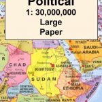
 Middle East: Maps International Political Wall Map
 NGS Executive Political World Wall Map ENLARGED, FRAMED
 World: National Geographic Society Decorator Style Political Wall Maps
 World Political – Sea Relief F&B Wall Map LAMINATED
 World NGS Explorer Executive Wall Map PAPER
 World NGS Explorer Executive Wall Map ENCAPSULATED
World Global Mapping Political Wall Map LARGE PAPER
World NGS Explorer Executive Wall Map ENCAPSULATED
World Global Mapping Political Wall Map LARGE PAPER
 World: Future Map Company Sinu-Mollweide Projection Political Wall Maps
 World F&B Political – Sea Relief Wall Map XXL LAMINATED
World Global Mapping Political Wall Map MEDIUM PAPER
World F&B Political – Sea Relief Wall Map XXL LAMINATED
World Global Mapping Political Wall Map MEDIUM PAPER
 World Political/Physical – Sea Relief F&B Wall Map LAMINATED with Metal Hanging Strips
 World F&B Physical – Sea Relief Wall Map
 South East Asia Global Mapping Political Wall Map PAPER
 World NGS Physical / Ocean Floor Wall Map ENCAPSULATED
 World NGS Physical / Ocean Floor Wall Map LARGE PAPER
 World Maps International Political Wall Map SMALL PAPER
World Maps International Glow in the Dark Wall Map
World Maps International Political Wall Map SMALL PAPER
World Maps International Glow in the Dark Wall Map
 World Maps International Political Wall Map LARGE PAPER
 World NGS Physical / Ocean Floor Wall Map LARGE ENCAPSULATED
 World Maps International Political Wall Map MEDIUM PAPER
World Global Mapping Political Wall Map MEDIUM ENCAPSULATED
World Maps International Political Wall Map MEDIUM PAPER
World Global Mapping Political Wall Map MEDIUM ENCAPSULATED
 NGS Executive Political World Wall Map 3-SHEET SET, ENCAPSULATED
 World & Flags Hema Political Pacific-Centred
 World Global Mapping Political Wall Map X-LARGE ENCAPSULATED
 World NGS Executive Wall Map PAPER
 World Maps International Political Wall Map SMALL PIN-BOARD FRAMED with flags
 World: Freytag & Berndt Political Wall Maps
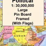 World Maps International Political Wall Map LARGE PIN-BOARD FRAMED with flags
 World Maps International Political Wall Map MEDIUM PIN-BOARD FRAMED with flags
 World NGS Executive Wall Map LARGE PAPER
 World Maps International Political Wall Map X-LARGE PAPER
 World Maps International Political Wall Map MEDIUM LAMINATED
 World NGS Executive Pacific-Centered Wall Map PAPER