Disclosure : This site contains affiliate links to products. We may receive a commission for purchases made through these links.
Windhoek
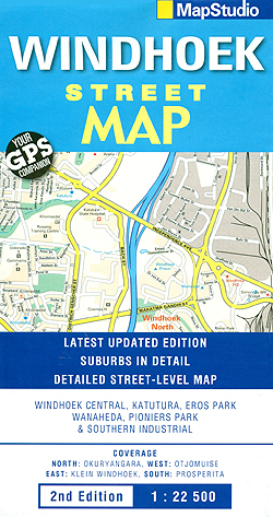
Windhoek with its outer suburbs on an indexed street plan at 1:22,500 from South Africa’s leading map publishers Map Studio. One way streets and traffic lights are marked, with symbols indicating a range of features for the tourist and resident alike: railway lines with stations, shopping centres, various services and municipal buildings, tourist information, places of interest, etc. Neighbourhoods are clearly named and colours distinguish land use, e.g. industrial areas, parks, built-up areas, etc. The plan is indexed and has a latitude/longitude grid at intervals of 1’.An inset shows the main highways approaching the city, including access from the Hosea Kutako International Airport.

Related Products:
 Windhoek F&B
 Namibia ITMB
 Namibia Map Studio Adventure Map
 Bloemfontein Pocket Tourist Map
 Port Elizabeth Pocket Tourist Map
 Jakarta ITMB
 Trujillo Metro Plan
 San Sebastian / Donostia
 Vitoria-Gasteiz
 Adana Main Roads Map
 Vaal Triangle
 Philadelphia & Mid-Atlantic States ITMB
 Manhattan Borch
 Greenland & North Pole ITMB
 Laos Periplus Travel Map
 South Africa Map Studio Pocket Map
 Iceland ITMB
 Brisbane Suburbs & City Centre UBD Gregory`s 418
 Reykjavik & SW Iceland ITMB
 Lรฉrida/Lleida
 Doha Street Plan
 Pamplona/Iruรฑa
 Dublin City Centre Tourist Map
 Paraguay – Bolivia South ITMB
 Blue Mountains Suburban Streets UBD Gregory`s 290
 Hanoi – Vietnam North ITMB
La Coruรฑa
Hanoi – Vietnam North ITMB
La Coruรฑa
 Sri Lanka Periplus Travel Map
Murcia
Sri Lanka Periplus Travel Map
Murcia
 Santander
 Figueres
 Namibia F&B
 Chad ITMB
Palma de Mallorca
Chad ITMB
Palma de Mallorca
 Cape Town & Peninsula NGS Adventure Map 3200
 Hawaii Reise Know-How
 Bhutan & Northeast India ITMB
รvila
Bhutan & Northeast India ITMB
รvila
 Alicante and the Towns of the Alicante Province
 Estonia & Tallinn ITMB