Disclosure : This site contains affiliate links to products. We may receive a commission for purchases made through these links.
Western USA – South Western Canada Michelin Regional 585
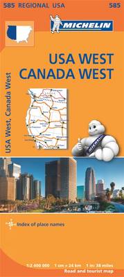
Western USA and South-Western Canada at 1:2,400,000 (1″ to 38 miles) on an indexed road map from Michelin with coverage extending eastwards to the eastern borders of Montana, Wyoming and New Mexico. In Canada the map extends to Edmonton in Alberta, covering all of the Banff and most of the Jasper National Park in the Canadian Rockies.The map is part of Michelin’s series covering USA on three maps at this scale. Road network indicates toll roads and clearly shows road numbers of interstate and state highways plus on selected local roads. Driving distances are marked on main routes in both miles and kilometres, and on selected state roads in kilometres only. State borders are clearly marked and the maps also show time zone boundaries. Topography is indicated by relief shading, with colouring for national/state parks and forests, Indian lands and restricted entry military zones. The maps have no geographical coordinates; each title is indexed.To see all the titles in this series, including more detailed coverage of New England and the Mid-Atlantic States, please click on the series link.

Related Products:
 Northeastern USA – Eastern Canada Michelin Regional 583
 Southeastern USA Michelin Regional 584
 USA: Michelin Regional Road Maps
 Midatlantic – Allegheny Highlands Michelin Regional 582
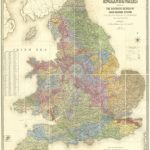
 Wales – South West England – Midlands Michelin Regional 503
 New England – Hudson Valley Michelin Regional 581
 Deep South – Mississippi to Florida Michelin Zoom 177
 South East England – Midlands – East Anglia Michelin Regional 504
 Poland South West Michelin Regional 557
 Belgium South Michelin Regional 534
 Northern England – Midlands Michelin Regional 502
 Netherlands South Michelin Regional 532
 Canada Central: Western Ontario, Manitoba, Saskatchewan Reise-Know-How Map
 Italy South Michelin Regional 564
 Scotland Michelin Regional 501 WATERPROOF
 Scotland Michelin Regional 501
 Portugal South Michelin Regional 593
 Texas – Oklahoma Michelin Zoom 176
 USA Michelin
 Southern Rockies – Arizona – Colorado – New Mexico – Utah Michelin Zoom 175
 Pacific Northwest – Washington – Oregon Michelin Zoom 171
 USA – Canada – Mexico Michelin Road Atlas 2021 SPIRAL-BOUND
 Languedoc-Roussillon Michelin Regional 526
 Aquitaine Michelin Regional 524
 Midi-Pyrรฉnรฉes Michelin Regional 525
 Germany Southwest Michelin Regional 545
 Paris & Surrounding Areas Michelin Regional 514
 Great Lakes Michelin Zoom 173
 Western Canada MapArt
 Brittany Michelin Regional 512
USA: Michelin Zoom Maps
Brittany Michelin Regional 512
USA: Michelin Zoom Maps
 Belgium North & Centre Michelin Regional 533
 Western Russia Michelin
 Rhรดne-Alpes Michelin Regional 523
 Canada Michelin
 Champagne-Ardenne Michelin Regional 515
 Auvergne – Limousin Michelin Regional 522
 North America Michelin Large Format Atlas 2021 – USA – Canada – Mexico
 Loire Valley Michelin Regional 517
 Franche-Comte Michelin Regional 520