Disclosure : This site contains affiliate links to products. We may receive a commission for purchases made through these links.
Wellington Complete Metromap
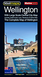
Street plan of the Wellington conurbation, including Johnsonville, the Hutt Valley, Porirua and the Kapiti Coast, with enlargements for city centres and the Picton Ferry Terminal, plus a comprehensive street index. The main plan covers the whole area at 1:35,000, showing names of various suburbs and clearly indicating main traffic arteries. One way streets, car parks, railway lines with stations, ferry terminals, public buildings, etc. are marked. The enlargement at 1:15,000 shows Wellington’s town centre in greater detail. Also included are enlargements, at varying scales, for the Picton Ferry Terminal and the centres of Johnsonville, Lower Hutt, Upper Hutt, Porirua, Pukerua Bay, Masterton with the UCOL Wairarapa Campus, Waikanae, Paraparaumu, Kapiti Village, Levin and Otaki.The plans show boundaries of postal districts and postcodes. An unusual feature of the map is an unobtrusive circular radius grid showing distance from the centre of Wellington.

Related Products:
 Auckland Complete
 Wellington City and District Pathfinder
 Wellington F&B
 Wellington – Wairarapa: Palmerston North, Levin, Masterton
 To War with Wellington
 South Island – New Zealand Kiwimaps Complete Drivers Atlas
 North Island – Eastern & Southern Kiwimaps
 Christchurch, Ashburton, Rangiora & 16 Canterbury Towns Kiwimaps
 North Island – New Zealand Kiwimaps Complete Drivers Atlas
 Santiago de Chile Trekkingchile Street Plan
 New Zealand ITMB
 Christchurch Visitors` Street Plan
 Okinawa & the Ryukyu Islands Periplus Travel Map
 New Zealand Kiwimaps Travel & Touring Map
 Hamilton, Cambridge, Te Awamutu Pocket Map
 Galway OSI Street Map
 Constanta Cartographia Street Plan
 Chard – Wellington & the Blackdown Hills 1896 – 311
 Dublin Borch
 Auckland & North Island ITMB
 Hong Kong Nelles
 Sofia Domino Street Plan
 NZ4634 Wellington Harbour Entrance and Plans of Wharves
 Dunedin, Mosgiel, Oamaru and Otago Towns Pocket Map
 Seville Central
 Bloomers, Biros and Wellington Boots: How the Names Became the Words
 New Zealand Kiwimaps Compact Travellers Atlas SPIRAL-BOUND
 Kiev Kartografija Street Plan
 South Island with 6 Town Centre Kiwimaps
 NZ4633 Wellington Harbour
 CHS Chart 7569 – Barrow Strait and Wellington Channel
 Florence Global Map Street Plan
New Zealand Kiwimaps Travellers Road Atlas
Florence Global Map Street Plan
New Zealand Kiwimaps Travellers Road Atlas
 Dublin City Centre Tourist Map
 Dushanbe
 East Brandenburg – Lower Silesia
 Geneva CityPocket Street Plan
 Bologna TCI Pocket Plan
 Taunton & Blackdown Hills – Wellington & Ilminster OS Explorer Active Map 128 (waterproof)