Disclosure : This site contains affiliate links to products. We may receive a commission for purchases made through these links.
Waterloo & Southwark 1914 – 76.3
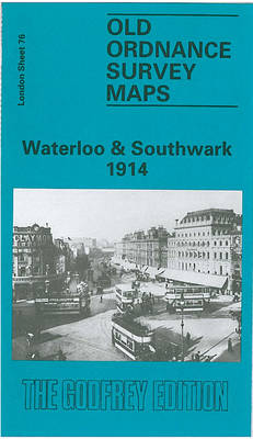
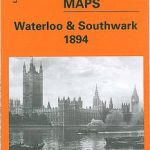
Waterloo and Southwark in 1914 in a fascinating series of reproductions of old Ordnance Survey plans in the Alan Godfrey Editions, ideal for anyone interested in the history of their neighbourhood or family. Three versions cover this area which includes much of Lambeth and Southwark, and the area now known as the South Bank. Coverage stretches from Waterloo Bridge eastward to Borough High Street, and from Waterloo Bridge southward to Lambeth Palace and Elephant & Castle. A small stretch of Westminster is also here, including the Houses of Parliament and New Scotland Yard. Other features include Lambeth Bridge, Hungerford Bridge; Charing Cross, Waterloo, Necropolis and Elephant & Castle stations, with many junctions and sidings; St Thomas`s Hospital, Bethlem Hospital, Southwark RC Cathedral, Metropolitan Tabernacle, St George`s Circus, Anchor Brewery, and countless factories, wharves, streets, prisons etc.About the Alan Godfrey Editions of the 25″ OS Series:Selected towns in Great Britain and Ireland are covered by maps showing the extent of urban development in the last decades of the 19th and early 20th century. The plans have been taken from the Ordnance Survey mapping and reprinted at about 15 inches to one mile (1:4,340). On the reverse most maps have historical notes and many also include extracts from contemporary directories. Most maps cover about one mile (1.6kms) north/south, one and a half miles (2.4kms) across; adjoining sheets can be combined to provide wider coverage.FOR MORE INFORMATION AND A COMPLETE LIST OF ALL AVAILABLE TITLES PLEASE CLICK ON THE SERIES LINK.

Related Products:
 Waterloo & Southwark 1894 – 76.2
 Bermondsey & Wapping 1914 – 77.3
 Holborn, The City & The Strand 1914 – 62.3
 Bethnal Green & Bow 1914 – 52.3
 Llantwit Major 1914
 Newcastle & Gateshead 1914 – 18b
 Kennington & Walworth 1871 – 89.1
 Old Kent Road 1914 – 90.3
Chigwell Station 1914
Old Kent Road 1914 – 90.3
Chigwell Station 1914
 Lewisham 1914 – 119.3
Jesmond 1914
Stourbridge South and Oldswinford 1914
Lewisham 1914 – 119.3
Jesmond 1914
Stourbridge South and Oldswinford 1914
 New Cross 1914 – 104.3
Finchfield and Wightwick 1914
New Cross 1914 – 104.3
Finchfield and Wightwick 1914
 Shoreditch 1914 – 51.3
Trimdon Grange 1914
Shoreditch 1914 – 51.3
Trimdon Grange 1914
 Leyton 1914
Kensington 1914 – 74.3
Leyton 1914
Kensington 1914 – 74.3
 Bermondsey & Wapping 1894 – 77.2
 Bermondsey & Wapping 1872 – 77.1
Pwllheli 1914
Bermondsey & Wapping 1872 – 77.1
Pwllheli 1914
 Rotherhithe 1914 – 78.3
Guildford 1895
Rotherhithe 1914 – 78.3
Guildford 1895
 Stoke Newington 1914 – 30.3
 Stepney & Limehouse 1914 – 64.3
 Tickhill 1901
Carlton Main & Shafton Two Gates 1914 – 263.13
Chigwell Row and Grange Hill 1914
The West End 1914 – 61.3
Wolverhampton Bushbury 1914
Birmingham West 1914
Gurnos 1914 – 43.14
Tickhill 1901
Carlton Main & Shafton Two Gates 1914 – 263.13
Chigwell Row and Grange Hill 1914
The West End 1914 – 61.3
Wolverhampton Bushbury 1914
Birmingham West 1914
Gurnos 1914 – 43.14
 Chesterfield 1914 – 25.06b
Duns & Greenlaw 1898 – 16.07
Coombeswood 1914
Sturminster Newton 1900
Chesterfield 1914 – 25.06b
Duns & Greenlaw 1898 – 16.07
Coombeswood 1914
Sturminster Newton 1900
 East Dulwich & Peckham Rye 1914 – 117.3
Paddington 1914 – 60.3
East Dulwich & Peckham Rye 1914 – 117.3
Paddington 1914 – 60.3
 Highbury & Islington 1914 – 39.3
 Shrewsbury West 1900