Disclosure : This site contains affiliate links to products. We may receive a commission for purchases made through these links.
Walking the Cotswold Way
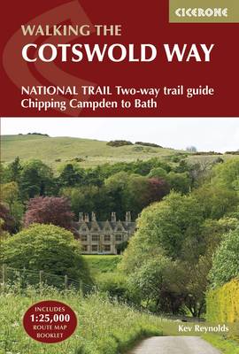
Guidebook to walking the Cotswold Way National Trail between Chipping Campden and Bath, across the Cotswolds AONB. The 102 mile (163km) route is described in both directions over 13 stages, of between 6 and 10 miles, depending on the existence of overnight accommodation. Camping options are sparse along the route. This guidebook is illustrated with maps and the author`s own full-colour photographs. The stage-by-stage route description is accompanied by overview maps at a scale of 1:100,000 (1cm to 1 mile). A more detailed map of the Way is supplied in booklet form, at a scale of 1:25,000, slid into the back of the book. The Cotswold Way became a National Trail in May 2007, despite having been a much-loved walking route for more than 35 years. It follows the Cotswold escarpment, with dramatic and far-reaching views across the Severn Vale towards the Welsh hills, plunging down to visit honey-coloured villages, old market towns and the elegant and historic city of Bath.

Related Products:
 Cotswold Way: An Archaeological Walking Guide
 Cotswold Way: Chipping Campden to Bath
 Cotswold Way: National Trail Guide
 Cotswold Way Cicerone Map Booklet
 Cotswold Way Harvey National Trail XT40
 Walking in the Cotswolds: 30 Classic Hill and Valley Routes
 Walking Cheshire`s Sandstone Trail Northern Eye Books Map-Guide
 South Downs Way (Trailblazer British Walking Guides): Practical guide with 60 Large-Scale Walking Maps (1:20,000) & Guides to 49 Towns & Villages – Planning, Places To Stay, Places to Eat: 2022
 Iceland, Walking and Trekking – 100 days of walking and multi-day treks
 The Cotswold Collection
 Walking the South West Coast Path: National Trail From Minehead to South Haven Point
 Exmoor & North Devon Coast Path, South-West-Coast Path Part 1: Minehead to Bude (Trailblazer British Walking Guide): Practical walking guide with 55 large-scale walking maps (1:20,000) and guides to 30 towns and villages – planning, places to stay, places
 Cotswold Way A-Z Adventure Atlas
 Thames Path:National Trail from London to the river`s source in Gloucestershire
 Walking the Via Francigena pilgrim route – Part 2: Lausanne and the Great St Bernard Pass to Lucca
 Walking the Via Francigena pilgrim route – Part 3: Lucca to Rome
 Walking and Trekking on Corfu: The Corfu Trail and 22 Outstanding Day-Walks
 Cornwall Coast Path – Bude to Plymouth (South West Coast Path Part 2)
 Coast to Coast Path (Trailblazer British Walking Guide): 109 Large-Scale Walking Maps & Guides to 33 Towns & Villages – Planning, Places to Stay, Places to Eat – St Bees to Robin Hood`s Bay
 Cotswold Cycling Country Lanes & Traffic-Free Family Routes
 Walking the Cape Wrath Trail: Backpacking through the Scottish Highlands: Fort William to Cape Wrath
 The Peddars Way and Norfolk Coast path: 130 mile national trail – Norfolk`s best inland and coastal scenery
 Glyndwr’s Way
 North Cotswold Classic Walks
 The South Downs Way Map Booklet
 Walking the Shropshire Way: A two-week circular trail including the Wrekin, Stiperstones and Wenlock Edge
 Cotswold Classic Walks
 Walking Hampshire`s Test Way: The long-distance trail and 15 day walks
 The Great Glen Way: Fort William to Inverness Two-Way Trail Guide
 The Snowdonia Way: A Walking Route Through Snowdonia from Machynlleth to Conwy
 Walking in County Durham: 40 walking routes exploring Pennine moors, river valleys and coastal paths
 Pearson`s Canal Companion – Severn and Avon: Mid-Worcestershire Ring and Cotswold Canals
 The Ridgeway National Trail: Avebury to Ivinghoe Beacon, Described in Both Directions
 Walking the Applalachian Trail
 Walking on Guernsey
 Walking the Streets of London
 Walking on Malta
 Yorkshire Coast Path: A guide to walking 120 miles of magnificent coastline from Redcar to the Humber
 South Cotswold Classic Walks
 Walking in Kent