Disclosure : This site contains affiliate links to products. We may receive a commission for purchases made through these links.
Wainwright Outlying Fells GuideUs Wall Map with a Tick List
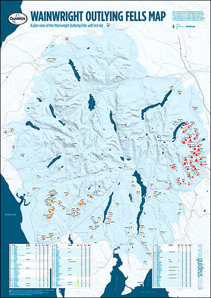
The Wainwright Outlying Fells of the Lake District presented on a wall map from GuideUs, size 59.5 x 84cm / 23.5″ x 33″ approx, each hill is numbered and cross-referenced to a list so that you can tick off the ones you have completed. The map shows the lesser fells around the perimeter of Lake District: north of Cockermouth, east of Ullswater and Haweswater, in the south around Lake Windermere, Coniston Water and Devoke Water, plus in the west north of Calder Bridge.The map shows the whole of the Lake District at 1:90,000 approx, with names of hills, hill groups, valleys, passes, lakes, major towns and main roads – please note that in the central part only the main peaks are marked. Below the map is a table listing the hills, by group rather than by height, with their altitudes in metres and feet, as well as Wainwright’s original values and the area of the Lake District the hill is located. Each area is clearly colour-coded both on the map and hill table. The map is printed on high quality 170gsm paper.Please note: GuideUs also publish a similar chart for the Wainwright Fells, available in two different sizes.
Related Products:
 Lake District – Wainwright Fells & Tick List GuideUs Wall Map SMALL
 Lake District – Wainwright Fells & Tick List GuideUs Wall Map LARGE
 Munro Map GuideUs Wall Map with Tick List
 The Wainwright Fells of the Lake District
 214 Wainwright Fells and the tarns of the Lake District Wall Map
 Snowdonia Mountain GuideUs Chart with Tick List
 Topographical Map of the Lake District – Wainwright Fells
 North Western Fells – Book 6 (Revised Edition)
 Wainwright`s Guides to the Lakeland Fells and Other Locations
 Western Fells – Book 7 (Revised Edition)
 Eastern Fells – Book 1 (Revised Edition)
 Far Eastern Fells – Book 2 (Revised Edition)
 Southern Fells – Book 4 (Revised Edition)
 Central Fells – Book 3 (Revised Edition)
 Wainwright Summits Collect and Scratch Print
 Peak Bagging: Wainwrights: 45 routes designed to complete all 214 of Wainwright`s Lake District fells in the most efficient way
 Northern Fells – Book 5 (Revised Edition)
 Far Eastern Fells – Book 2 (Readers Edition)
 Wainwright Map 6 – North Western Fells
 Wainwright Map 7 Western Fells
 North Western Fells – Book 6 (Readers Edition)
 Eastern Fells – Book 1 (Readers Edition)
 Wainwright Map 1 – Eastern Fells
 Wainwright Maps (4): The Southern Fells
 Wainwright Maps (2): The Far Eastern Fells
 Wainwright Maps (3): The Central Fells
 Wainwright Maps (5): The Northern Fells
 Lake District – Northern Fells Adventure Atlas
 The High Fells of Lakeland
 Walking the Lake District Fells – Coniston: Coniston Fells, Duddon Valley and Eskdale
 Wainwright Maps of the Lakeland Fells
 Walking the Lake District Fells – Borrowdale: Scafell Pike, Catbells, Great Gable and the Derwentwater Fells
 Western Fells – Book 7 (Readers Edition)
 Southern Fells – Book 4 (Readers Edition)
 Walking the Lake District Fells – Keswick: Skiddaw, Blencathra and the North
 Walking the Lake District Fells – Langdale: The Langdale Pikes and Bowfell
 Lake District – Low Fells
 Walking the Tour of the Lake District: A nine-day circuit of Cumbria`s fells, valleys and lakes
 Lake District – High Fells
 Lakeland Fells: Keswick & the North (25 walks)


