Disclosure : This site contains affiliate links to products. We may receive a commission for purchases made through these links.
Visp Swisstopo 274
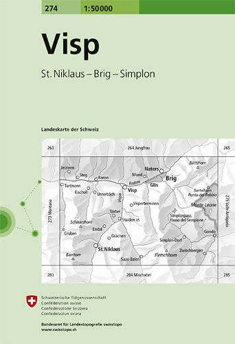
Visp, map No. 274, in the standard topographic survey of Switzerland at 1:50,000 from Swisstopo, i.e. without the special overprint highlighting walking trails, local bus stops, etc, presented in Swisstopo’s hiking editions of the 50K survey. Coverage extends southwards from the Rhone Valley and Brig to include the lower part of the Mattertal beyond Grรคchen and St. Niklaus, the lower part of the Saastal and the Simplon Pass.Highly regarded for their superb use of graphic relief and hill shading, the maps give an almost 3-D picture of Switzerland`s mountainous terrain. Contours are at 20m intervals. All the maps have a 1-km grid with the Swiss national coordinates. This standard version of the 50K survey covers the whole country on 78 small format sheets, with special larger format maps published for several popular tourist destinations. Small format sheets cover an area of 35 x 24 km (21 x 15 miles approx) and have map legend in the language of the area covered by the map. The special larger sheets cover 50 x 35 km (31 x 22 miles approx) and have no map legend, but a separate leaflet can be provided instead.PLEASE NOTE: the hiking editions of the 1:50,000 Swisstopo survey are listed on our website in a separate series.

Related Products:
 Unterengadin / Lower Engadine Swisstopo 5017
Tarasp Swisstopo 249
Unterengadin / Lower Engadine Swisstopo 5017
Tarasp Swisstopo 249
 Liestal Swisstopo 214
Zurich Swisstopo 225
Solothurn Swisstopo 233
Avenches Swisstopo 242
Liestal Swisstopo 214
Zurich Swisstopo 225
Solothurn Swisstopo 233
Avenches Swisstopo 242
 Bern Swisstopo 243
Sardona Swisstopo 247
Bern Swisstopo 243
Sardona Swisstopo 247
 La Sarraz Swisstopo 251
 Sustenpass Swisstopo 255
 Safiental Swisstopo 257
 Montana Swisstopo 273
 Disentis / Mustรฉr Swisstopo 256
Frauenfeld Swisstopo 216
Disentis / Mustรฉr Swisstopo 256
Frauenfeld Swisstopo 216
 Willisau Swisstopo 234
Klausenpass Swisstopo 246
Willisau Swisstopo 234
Klausenpass Swisstopo 246
 Bulle Swisstopo 252
Gantrisch Swisstopo 253
Bulle Swisstopo 252
Gantrisch Swisstopo 253
 Nufenenpass Swisstopo 265
Malcantone Swisstopo 286
Nufenenpass Swisstopo 265
Malcantone Swisstopo 286
 Delรฉmont Swisstopo 223
 Basel Swisstopo 213
Olten Swisstopo 224
Rapperswil Swisstopo 226
Basel Swisstopo 213
Olten Swisstopo 224
Rapperswil Swisstopo 226
 Escholzmatt Swisstopo 244
Valle Leventina Swisstopo 266
Escholzmatt Swisstopo 244
Valle Leventina Swisstopo 266
 Gotthard Swisstopo 5001
 Domodossola Swisstopo 285
Prรคttigau Swisstopo 248
Domodossola Swisstopo 285
Prรคttigau Swisstopo 248
 Schaffhausen Swisstopo 205
Vallon de St-Imier Swisstopo 232
Boncourt Swisstopo 212
Konstanz Swisstopo 207
Schaffhausen Swisstopo 205
Vallon de St-Imier Swisstopo 232
Boncourt Swisstopo 212
Konstanz Swisstopo 207
 Toggenburg – Sarganserland Swisstopo 5015
Flumserberge – Prรคttigau Swisstopo 5012
Toggenburg – Sarganserland Swisstopo 5015
Flumserberge – Prรคttigau Swisstopo 5012
 Locarno – Lugano Swisstopo 5007
 Gantrisch – Thunersee Swisstopo 5018
Walenstadt Swisstopo 237
Gantrisch – Thunersee Swisstopo 5018
Walenstadt Swisstopo 237
 San Bernardino Swisstopo 267
 Gressoney Swisstopo 294