Disclosure : This site contains affiliate links to products. We may receive a commission for purchases made through these links.
Virgin Islands (US and British) ITMB

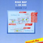
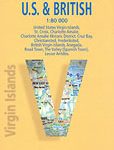
Virgin Islands, both US and British, at 1;50,000 from ITMB on a double-sided, indexed map printed on light, waterproof and tear-resistant paper, with eight insets showing street plans of main towns across the whole group.On one side are the US Virgin Islands, accompanied by street plans of Charlotte Amalie on St. Thomas, including an enlargement of its historic district; Chistiansted, Friedensfeld and Frederiksted on St. Croix; and Cruz Bay on St. John.On the reverse are the British Virgin Islands, with street plans of Road Town on Tortola and The Valley (Spanish Town) on Virgin Gorda.The map shows the road network on the islands, with symbols indicating various places ot interest including campsites, beaches, scuba diving/snorkeling/surfing sites, national park and other protected areas, including wildlife and bird sanctuaries, sport and recreational facilities, marinas, etc. Swamps or mangrove areas, and in the coastal waters coral reefs are marked. Topography is shown by altitude colouring and contours at 50m intervals, but with peak heights shown in feet. Latitude and longitude are expressed in decimal parts of a degree, with the lines drawn at 0.01ยบ intervals. Each side of the map has a separate index.The street plans highlight locations of selected hotels, local markets and various tourist facilities, places of interest, etc.

Related Products:
 Virgin Islands (US and British)
 Virgin Islands Borch
 British Virgin Islands Franko`s Map-Guide
 Fodor`s U.S. & British Virgin Islands
 A231 Virgin Islands: St Thomas to Virgin Gorda
 Cayman Islands & Jamaica ITMB
 US Virgin Islands Adventure and Dive Map/Guide
 Imray Chart A231: Virgin Islands St Thomas to Virgin Gorda: 2019
 Cruising Guide to the Virgin Islands 2017/18
 Puerto Rico, the Spanish, US and British Virgin Islands
 Puerto Rico & US Virgin Islands ITMB
 Bahamas ITMB
 British Virgin Islands Civil Ensign – 1yd – Printed
 British Virgin Islands Civil Ensign – 2yd – Printed
 British Virgin Islands Civil Ensign – 1yd – Sewn
 British Virgin Islands Civil Ensign – 2yd – Sewn
 Caribbean Islands East & South ITMB Travel Atlas
 British Virgin Islands Civil Ensign – 1/2 yard – Printed
 A232 Virgin Islands: Tortola to Anegada
 Dominica & Saint Lucia ITMB
 Grenada to the Virgin Islands – Cruising Guide
 Imray Chart A232: Virgin Islands Tortola to Anegada: 2019
 A23 Virgin Islands and St Croix
 British Columbia South ITMB
 Admiralty Chart 2020 – Harbours and Anchorages in the British Virgin Islands
 British Columbia ITMB Pocket Road Atlas
 A233 Virgin Islands (Charts A231 and A232 back-to-back without text)
 Polynesian Islands ITMB Travel Atlas
 Hawaii & Honolulu ITMB
 Caribbean – Central America – Virgin Islands – Bahamas
 Imray Chart A233: Virgin Islands Double-sided sheet combining charts A231 and A232: 2019
 Fiji & Tonga ITMB
 Guyana, Suriname & French Guiana ITMB
 Caribbean Islands Western Half ITMB Travel Atlas
 Lofoten and Vesteralen Islands
 Galapagos Islands – Quito & Guayaquil ITMB
 Bali & Lombok ITMB
 Kazakhstan & Uzbekistan ITMB
 Virgin Islands (GB/USA) Flexi Map OUT OF PRINT