Disclosure : This site contains affiliate links to products. We may receive a commission for purchases made through these links.
Varanger Nordeca Tourist Route 20018
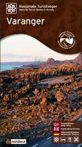
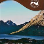
This Varanger National Tourist Route Map belongs to a series of 18 map and postcards sets describing popular tourist routes all over Norway. The map set includes a map in 1: 100,000 presenting an accurate topography (based on the Norwegian topographic survey) which describes local footpaths, cycle or ski routes, sport and recreational facilities, places of interest, places to stay and eat, viewpoints.Varanger National Tourist Route is a 160 kilometre-long stretch of road between Varangerbotn and Hamningberg in the county of Finnmark in Arctic Norway.Far to the north and furthest to the east in Norway, where the sky meets the sea, the road follows the coast towards the ice-cold Barents Sea. The road along the Varanger Peninsula begins among the sheltered birch forests and bogs of Varangerbotn and ends in a lunar landscape of jagged cliffs at the world`s end.Fishing, migrations and trade have made Varanger an Arctic melting pot of peoples and cultures. The proximity to Russia with the Pomor trade, Finnish immigration and Sami traditions are evident in the contrasting traditions and the exciting cultural history.Several descriptions and illustrations are included in the map to deliver a good visual representation of the trip.The set features:One map: scale 1:100,000 Text in three languages (Norwegian, English and German)5 Postcards (13.5x25cm)To see the list of other titles in this series, please click on the series link.

Related Products:
 Havoysund Nordeca Tourist Route 20017
 Sognefjellet Nordeca Tourist Route 20008
 Ryfylke Nordeca Tourist Route 20002
 Aurlandsfjellet Nordeca Tourist Route 20005
 Old Strynefjellsvegen Nordeca Tourist Route 20009
 Atlantic Road Nordeca Tourist Route 20012
 Valdresflye Nordeca Tourist Route 20006
 Gaularfjellet Nordeca Tourist Route 20007
 Lofoten Nordeca Tourist Route 20014
 Helgeland Coast North Nordeca Tourist Route 20013
 Norway: Nordeca Regional Touring Maps
 Denmark Tourist Map – Major Cities with the Marguerite Route
 Folgefonna National Park Nordeca 2663
Garden Route & Route 62 Map Studio
Folgefonna National Park Nordeca 2663
Garden Route & Route 62 Map Studio
 Norway: Nordeca 500K Regional Road Maps
 Norway Nordeca Sightseeing Map 6010
 Jรธlster Nordeca 2568
 Huldreheimen Nordeca 2489
 Fjordruta Nordeca 2607
 Forollhogna Nordeca 2731
 Reineskarvet Nordeca 2385
 Tafjordfjella Nordeca 2533
 Lygna Nordeca 2600
 Trondheim Nordeca 2665
 Lysefjorden Nordeca 2681
 Skarverennet Nordeca 2703
 Romeriksรฅsene Nordeca 2225
 Lofoten Nordeca 2549
 Blefjell Nordeca 2207
 Lifjell Nordeca 2219
 Norway Nordeca Road Map
 Jotunheimen Nordeca 2215
 Femunden Nordeca 2559
 Rondane Nordeca 2716
 Rendalen Nordeca 2753
 Ringebu Nordeca 2509
 Aurlandsdalen Nordeca 2565
 Nesbyen Nordeca 2573
 Skarvheimen Nordeca 2661
 Eidfjord Nordeca 2677