Disclosure : This site contains affiliate links to products. We may receive a commission for purchases made through these links.
Vancouver & Greater Vancouver ITMB
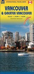
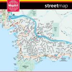
Street plan of Vancouver on waterproof and tear-resistant map from locally- based ITMB, combining on one side coverage of the central districts with an enlargement for the downtown area, plus on the reverse a map of the city with its outer suburbs, extending east to Langley and north to West Vancouver.On one side the city’s central districts are presented at 1:20,000, with coverage extending east to the Pacific National Exhibition Grounds. Stations of the rapid transit lines are clearly marked and named; the plan also shows the B-line bus route with stops and the False Creek trolley route. For drivers main traffic arteries are highlighted and locations of petrol stations are marked. Symbols indicate various facilities and places of interest. Downtown Vancouver is shown in greater detail on an enlargement at 1:13,000, with additional markings for numerous hotels. Selected streets are annotated with block numbers. Street index is supplemented by an additional list of points of interest.On the reverse a map at 1:50,000 shows Vancouver with its outer suburbs, including access to the international airport. As on the main plan, railway and rapid transit stations are clearly shown, principal traffic routes are highlighted, and various facilities are marked. Also provided is a diagram of the rapid transit network.

Related Products:
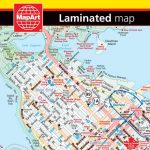
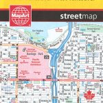 Vancouver & Area MapArt Street Plan
 Vancouver FastTrack
 Fraser Valley and Vancouver ITMB
 Vancouver – Fraser Valley
 Vancouver Greater and Fraser Valley Street Atlas Deluxe Edition
 Montreal & Southern Quebec ITMB
 Vancouver Borch
 San Francisco & Northern California ITMB
 Vancouver and Area Pocket Street Atlas
 Greater Victoria BC MapArt
 Hong Kong & Region ITMB
 Vancouver Island ITMB
 Seattle & Northwest USA ITMB
 Kyoto & Japan West ITMB
 Jakarta ITMB
 Sydney & Australia East ITMB
 Los Angeles & Southern California ITMB
 Quito & Central Ecuador ITMB
 San Diego & USA South West Border ITMB
 Las Vegas ITMB
 Quebec & Ontario ITMB Travel Atlas
 Osaka & Western Japan ITMB
 Hanoi – Vietnam North ITMB
 Sao Paulo & Brazil South Coast ITMB
 Accra & Ghana South ITMB
 Lima & Central Peru ITMB
 Iran & Tehran ITMB
 Mumbai / Bombay – India West Coast ITMB
 Manhattan & New York State ITMB
 Zurich & Switzerland NW ITMB
 Singapore & Malay Peninsula ITMB
 Jerusalem & Holy Land ITMB
 Philadelphia & Mid-Atlantic States ITMB
 Argentina South & Tierra del Fuego ITMB
 Greater Brussels Hike & Bike Map
 Tel Aviv-Jaffa & Central Israel ITMB
 Greater Oslo Cappelen Street Plan
 Tehran & Northern Iran ITMB
 Taiwan & Taipei ITMB
 North Vancouver – Port Coquitlam ITMB