Disclosure : This site contains affiliate links to products. We may receive a commission for purchases made through these links.
Valls d’ร€neu – Mont Valier – Mont-roig – Vall de Montgarri Editorial Alpina 2-Map Set
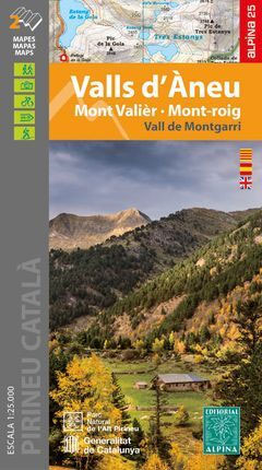
: Hiking map and guidebook’
: Scale 1:25.000′
: Equidistance contours: 10 m distance’
: Master contours: at 50 m’
: Shady relief’
: Compatible with GPS’
: Marked routes’
: Land use symbolized at three levels’
: Guidebook with hikes, potholing, gully descent, climbing, mountain biking and all the facts of interest

Related Products:
 Collsacabra – Vall de Sau Editorial Alpina
 Pica d`Estats – Mont-roig – Vall Ferrera – Valls de Cardos Editorial Alpina
 Posets – Perdiguero Editorial Alpina
 Pica d`Estats – Mont-roig Editorial Alpina
 l’Alta Garrotxa – les Salines and el Vallespir Editorial Alpina
 Vall de Barravรฉs – Ribagorรงa Editorial Alpina
 Gran Canaria Editorial Alpina 5-Map Set
 Congost de Mont-rebei Editorial Alpina
 Puigmal – Vall de Nuria – Ulldeter Editorial Alpina
 Vall de Lord – Port del Comte Editorial Alpina
 Pyrรฉnรฉes Ariรฉgeoises – Mont Valier – Pique d`Estats IGN 75020
 Vall de Boรญ – Aigรผestortes PN Editorial Alpina
 Vall Fosca – Montsent de Pallars Editorial Alpina 2-Map Set
 Ibiza – Formentera Editorial Alpina
 Montseny Editorial Alpina
 Valles de Belagua y Roncal Editorial Alpina
 Rasos de Peguera – Serra d`Ensija Editorial Alpina
 Catllarร s – Picancel Editorial Alpina
Val d`Aran – Mauberme – Montardo – Molieres Editorial Alpina
Cingles de Berti – Sant Miquel des Fai Editorial Alpina
Garraf – la Morella – Eramprunya Editorial Alpina
Catllarร s – Picancel Editorial Alpina
Val d`Aran – Mauberme – Montardo – Molieres Editorial Alpina
Cingles de Berti – Sant Miquel des Fai Editorial Alpina
Garraf – la Morella – Eramprunya Editorial Alpina
 Muntanya d’Alinyร Editorial Alpina
 Ripollรจs Editorial Alpina
 Mallorca Central Plain – East and South Coasts Editorial Alpina
Puigsacalm – Bellmunt Editorial Alpina
Val d`Aran by UTMB Editorial Alpina Trail running race Map
Valles de Ansรณ & Echo Editorial Alpina
Mallorca Central Plain – East and South Coasts Editorial Alpina
Puigsacalm – Bellmunt Editorial Alpina
Val d`Aran by UTMB Editorial Alpina Trail running race Map
Valles de Ansรณ & Echo Editorial Alpina
 El Turbรณn ‘“ Alto Valle de Isรกbena Editorial Alpina
Spain: Editorial Alpina Walking Maps
Collserola Parc Natural Editorial Alpina
Montseny NP – Turo de l`Home – Les Agudas – Matagalls – la Calma Editorial Alpina 2-Map Set
El Turbรณn ‘“ Alto Valle de Isรกbena Editorial Alpina
Spain: Editorial Alpina Walking Maps
Collserola Parc Natural Editorial Alpina
Montseny NP – Turo de l`Home – Les Agudas – Matagalls – la Calma Editorial Alpina 2-Map Set
 Valles de Irati y Aezkoa Editorial Alpina
 Ordesa and Monte Perdido National Park 2-Map Set Editorial Alpina
Ordesa – Monte Perdido National Park Editorial Alpina 2-Map Set
Ordesa and Monte Perdido National Park 2-Map Set Editorial Alpina
Ordesa – Monte Perdido National Park Editorial Alpina 2-Map Set
 Montgrony – Fonts del Llogregat – Parc Natural del Cadรญ-Moixerรฒ Editorial Alpina
 Sรณller – Mallorca Editorial Alpina Map & Guide ENGLISH
 Macizo de Monte Perdido – Valle de Ordesa – Pineta Editorial Alpina
Moixerรณ – La Tosa – Cadรญ-Moixerรณ Natural Park Editorial Alpina
Sant Llorenc del Munt i l`Obac Editorial Alpina
Macizo de Monte Perdido – Valle de Ordesa – Pineta Editorial Alpina
Moixerรณ – La Tosa – Cadรญ-Moixerรณ Natural Park Editorial Alpina
Sant Llorenc del Munt i l`Obac Editorial Alpina
 Valle de Canfranc – Valle de Aisa – Candanchu – Astun Editorial Alpina