Disclosure : This site contains affiliate links to products. We may receive a commission for purchases made through these links.
Valle Maira l`Escursionista Editore
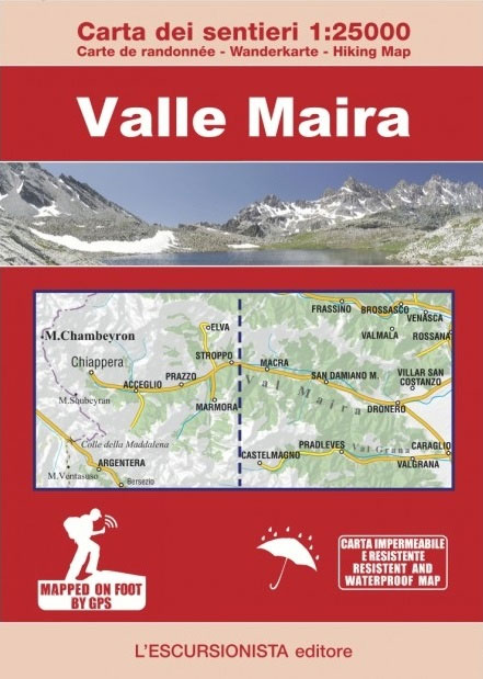
Valle Maira, at 1:25,000 on a waterproof and tear-resistant, double-sided, contoured and GPS-compatible map from the Istituto Geografico Adriatico with an overprint highlighting numerous local and long-distance hiking trails, including the GTA (Grande Traversata delle Alpi). The map shows various types of accommodation (huts and refuges, B&Bs, country inns, campsites, etc), food shops and cash dispensers, etc. Very clear cartography with contours at 25m intervals, shading, fine graphic relief and numerous spot heights provides an excellent representation of the terrain. The map has a 1-km UTM grid, plus latitude and longitude lines at intervals of 5’. Map legend includes English.This title shows an area to the south of the publishers’ series of maps covering the northern part of the Italian Alps ‘“ to see the list of titles for the region from the Swiss border to Monte Viso / Monviso please click on the series link.

Related Products:
 Val Soana – Valle di Ribordone – Valle di Locana L`Escursionista Editore 15
 Valle dell`Orco – Gran Paradiso L`Escursionista Editore 14
 Gran San Bernardo – Valle di Ollomont L`Escursionista Editore 5
 Dora Baltea Canavesana – Valchiusella – Valle Sacra L`Escursionista Editore 16
Valle di Cogne – Gran Paradiso L`Escursionista Editore 10
Dora Baltea Canavesana – Valchiusella – Valle Sacra L`Escursionista Editore 16
Valle di Cogne – Gran Paradiso L`Escursionista Editore 10
 Valle Centrale – Saint-Barthรฉlemy – Saint-Marcel – Val Clavalite L`Escursionista Editore 13
 Bassa Valle Varaita – Bassa Valle Maira Fraternali Editore 12
Valpelline – Saint-Barthรฉlemy L`Escursionista Editore 6
Bassa Valle Varaita – Bassa Valle Maira Fraternali Editore 12
Valpelline – Saint-Barthรฉlemy L`Escursionista Editore 6
 Bernina – Valmalenco – Sondrio L`Escursionista Editore 21
 Valgrisenche – Val di Rhemes – Valsavarenche L`Escursionista Editore 3
 Val di Champorcher – Mont Avic L`Escursionista Editore 11
Basse valli d`Ayas e del Lys L`Escursionista Editore 12
Alte Valli di Lanzo – Val Grande – Val d`Ala – Val di Viu L`Escursionista Editore 17
Val di Champorcher – Mont Avic L`Escursionista Editore 11
Basse valli d`Ayas e del Lys L`Escursionista Editore 12
Alte Valli di Lanzo – Val Grande – Val d`Ala – Val di Viu L`Escursionista Editore 17
 Cervino – Monte Rosa – Valtourenche – Valle di Champorcher L`Escursionista Editore
 Valtournenche – Monte Cervino / Matterhorn – Val d`Ayas West L`Escursionista Editore 7
 La Thuile ‘“ Haute Tarentaise l`Escursionista Editore 01
 Valsavarenche – Gran Paradiso L`Escursionista Editore 9
 Monte Bianco / Mt Blanc – Courmayeur L`Escursionista Editore 1
 Valle Maira – Acceglio 25K IGC Map No. 111
 Monte Rosa – Ayas – Gressoney – Alagna L`Escursionista Editore 8
 Conca di Aosta – Mont Emilius – Mont Fallere L`Escursionista Editore 4
Italy: L`Escursionista Editore 25K Hiking Maps of the Italian Alps
Conca di Aosta – Mont Emilius – Mont Fallere L`Escursionista Editore 4
Italy: L`Escursionista Editore 25K Hiking Maps of the Italian Alps
 Alta Valle Maira
 La Thuile ‘“ Piccolo San Bernardo L`Escursionista Editore 2
Valle Maira l`Escursionista Mountain Bike Map
La Thuile ‘“ Piccolo San Bernardo L`Escursionista Editore 2
Valle Maira l`Escursionista Mountain Bike Map
 Tour of the Matterhorn / Cervino L`Escursionista Editore Map-Guide
 Elba L`Escursionista Editore
 Val Maira – Val Grana – Valle Stura – Valle Gesso Fraternali Editore 50-3
 Tour of Saint-Bernard L`Escursionista Editore Map-Guide
 Tour of the Vallรฉe du Trient L`Escursionista Editore Map-Guide
Alta Valle Susa – Bardonecchia – Oulx Fraternali Editore 01
Bassa Valle Susa – Musine – Val Sangone – Collina di Rivoli Fraternali Editore 04
Tour of the Vallรฉe du Trient L`Escursionista Editore Map-Guide
Alta Valle Susa – Bardonecchia – Oulx Fraternali Editore 01
Bassa Valle Susa – Musine – Val Sangone – Collina di Rivoli Fraternali Editore 04
 Alta Valle Susa – Alta Val Chisone Fraternali Editore 02
 Tour du Mont Blanc L`Escursionista Editore Map-Guide
 Valle de Canfranc – Valle de Aisa – Candanchu – Astun Editorial Alpina
 Monviso – Valle Varaita – Valle Po – Valle Pellice IGC 106
 Italy/France/Switzerland: L`Escursionista Editore Maps of High Alpine Tours
 Bagno di Romagna Monti Editore 19
 La Valpelline – Valle di Ollomont – Valle di St. Barthelemy 30K IGC Map
 Alta Valle del Metauro: Valle del Candigliano, Monte Nerone, Monte Catria