Disclosure : This site contains affiliate links to products. We may receive a commission for purchases made through these links.
Valencia Michelin City Map
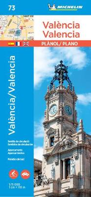
Michelin’s street plan of Valencia at 1:11,000 is primarily designed to be used for access to the city centre the city by car, given its detailed presentation of dual carriageways and road junctions. Main traffic routes across the city are highlighted, one way streets are marked, and locations of car parks are indicated. The metro stations are marked and a separate diagram presents the whole network. Also shown are numerous taxi ranks. The plan highlights and names public buildings and various facilities. The city centre is shown in greater detail on a separate enlargement. Street index is on the same side as the map. Map legend includes English.To see the list of titles in this series please click on the series link.

Related Products:
 Granada Michelin City Map
 Malaga Michelin City Map
 Berlin Michelin City Map
 Seville Michelin City Map
 Lisbon Michelin City Plan and Index
 Palma de Mallorca Michelin City Map
 London Michelin City Map
 Bilbao Michelin City Map
 Porto Michelin City Plan and Index
 Venice Michelin City Map
 Amsterdam Michelin City Map
 San Sebastian / Donostia Michelin City Map
 New York City – Manhattan Michelin City Plan and Index
 Florence Michelin City Map
 La Coruรฑa Michelin City Map
 Santander Michelin City Map
 Girona/Gerona Michelin City Map
 Brussels Hike & Bike Map
 Greater Brussels Hike & Bike Map
 Halle Forest Hike & Bike Map
 Benidorm
 Liege Michelin City Plan 99
 Valencia
 Amsterdam Michelin Citymap
 Ghent Michelin City Plan 41
 Lisbon Michelin Citymap
 Kiev F&B City Pocket
 Zaragoza
 New York Michelin Citymap
 Paris par Arrondissement Michelin ZOOM
 Bruges Michelin City Plan 69
Vigo and Pontevedra
Bruges Michelin City Plan 69
Vigo and Pontevedra
 Barcelona Michelin City Plan and Index
 Barcelona Michelin Citymap
 Munich F&B
 Michelin City Maps
 Warsaw Marco Polo City Map
 Helsinki City Map & Guide
 Alicante and the Towns of the Alicante Province
 Munich F&B Wall Map