Disclosure : This site contains affiliate links to products. We may receive a commission for purchases made through these links.
Valdresflye Nordeca Tourist Route 20006

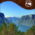
This Valdresflye National Tourist Route Map belongs to a series of 18 map and postcards sets describing popular tourist routes all over Norway. The map set includes a map in 1: 50,000 presenting an accurate topography (based on the Norwegian topographic survey) which describes local footpaths, cycle or ski routes, sport and recreational facilities, places of interest, places to stay and eat, viewpoints.Valdresflye National Tourist Route is a 49-kilometre-long stretch of road between Garli and Hindsรฆter, with a small scenic detour to Lake Gjende in the county of Oppland in Eastern Norway.The landscape along the route varies from open stretches of cultivated land to mountain areas with summer farms. The road reaches its highest point at 1,389 metres above sea level.The area around Lake Gjende is an important gateway to Jotunheimen National Park. The lodge at Gjendesheim is the point of departure for the Norwegian Trekking Association`s largest network of hiking paths. Outdoor enthusiasts young and old can put on their walking boots and enjoy the clear lakes, stony screeds and pleasant paths, with challenging peaks offering tempting goals. If you cross the Besseggen Ridge and Bukkelรฆgeret, you follow in the footsteps of Peer Gynt.On the way to Valdresflye you pass the well-kept cultural landscape of Heidal, Sjodalen and Valdres. You can also go rafting on the Sjoa River, an experience that really gets your adrenaline going.Several descriptions and illustrations are included in the map to deliver a good visual representation of the trip.The set features:One map: scale 1:50,000 Text in three languages (Norwegian, English and German)5 Postcards (13.5x25cm)To see the list of other titles in this series, please click on the series link.

Related Products:
 Aurlandsfjellet Nordeca Tourist Route 20005
 Havoysund Nordeca Tourist Route 20017
 Varanger Nordeca Tourist Route 20018
 Sognefjellet Nordeca Tourist Route 20008
 Old Strynefjellsvegen Nordeca Tourist Route 20009
 Gaularfjellet Nordeca Tourist Route 20007
 Atlantic Road Nordeca Tourist Route 20012
 Ryfylke Nordeca Tourist Route 20002
 Lofoten Nordeca Tourist Route 20014
 Helgeland Coast North Nordeca Tourist Route 20013
 Norway: Nordeca Regional Touring Maps
 Lake Balaton Cartographia Tourist Map 4
 Folgefonna National Park Nordeca 2663
 Denmark Tourist Map – Major Cities with the Marguerite Route
 Danube-Lake Constance Cycle Route – Upper Swabia-Allgรคu Cycle Route Bikeline Map-Guide
 El Ports: Southern Stars Long-distance Hiking Route
 Hjelmelandsheiane Nordeca 2232
 Suldalsheiene Nordeca 2228
 Norway Walking
Garden Route & Route 62 Map Studio
Norway Walking
Garden Route & Route 62 Map Studio
 Bialystok Environs – Narwianski National Park ExpressMap Tourist Map
 Jรธlster Nordeca 2568
 Huldreheimen Nordeca 2489
 Fjordruta Nordeca 2607
 Forollhogna Nordeca 2731
 Norefjell – Eggedal Nordeca 2525
 Sigdal – Rollag Nordeca 2571
 Reineskarvet Nordeca 2385
 Tafjordfjella Nordeca 2533
 Lygna Nordeca 2600
 Trondheim Nordeca 2665
 Lysefjorden Nordeca 2681
 Skarverennet Nordeca 2703
 Romeriksรฅsene Nordeca 2225
 Lofoten Nordeca 2549
 Blefjell Nordeca 2207
 Lifjell Nordeca 2219
 Femunden Nordeca 2559
 Rondane Nordeca 2716
 Rendalen Nordeca 2753