Disclosure : This site contains affiliate links to products. We may receive a commission for purchases made through these links.
USA Northwest – OR, WA Reise Know-How
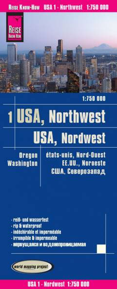
North Western USA: Washington State and Oregon at 1:750,000 in a series of waterproof and tear-resistant, indexed regional maps of USA from Reise Know-How’s highly acclaimed World Mapping Project, combining detailed presentation of the road network with topographic and tourist information. The map is double-sided to provide the best balance between detailed scale and a convenient size sheet, dividing the two states north/south with the whole of Washington and northern Oregon on one side and the remainder of Oregon on the reverse.Maps in this series have altitude colouring with spot heights to show each region’s topography, with national parks and other protected areas, as well as American Indian Reservations and restricted entry zones clearly marked. Road network indicates toll roads and scenic routes. Driving distances are shown in miles. Railways and, where appropriate, ferry routes are marked. The maps show both names and boundaries of local counties. Symbols highlight a variety of places of interest, including historical sites, amusement parks, natural features, golf courses and wintersport areas, etc. Each map includes an index of localities and has a latitude and longitude grid (in this title at intervals of 30’). Map legend includes English.To see other titles in this series please click on the series link.

Related Products:
 USA North-Eastern: Maine to WashingtoN DC (CT, DE, ME, MD, MA, NH, NJ, NY, OH, PA, RI, VT, WV) Reise-Know-How Map
 USA Southeast Reise Know-How
 USA North – ID, MT, NE, ND, SD, WY Reise Know-How
 Hawaii Reise Know-How
 USA South-Central: Kansas – Oklahoma – Texas Reise-Know-How Map
 Florida Reise Know-How
 Alaska Reise Know-How
 USA Midwest – IL, IN, IA, MI, MN, MO, WI Reise Know-How
 California Reise Know-How
 New England Reise Know-How
 USA Southwest Reise Know-How
 India Northwest Reise Know-How
 USA: Reise Know-How Regional Touring Maps
 Northwest USA – Pacific Northwest Borch
 Pacific Northwest – Washington – Oregon Michelin Zoom 171
 Mallorca North Reise Know-How
 Pacific Northwest De Long Wine Wall Map
 Seattle & Northwest USA ITMB
 Pacific Northwest De Long Wine Map
 Pacific Northwest NGS Adventure Map 3118
 Inland Empire – Inland Pacific Northwest WA/ID/OR
 Istria Reise Know-How
 Mallorca East Reise Know-How
 Oregon Benchmark Recreational Map
 Mallorca South Reise Know-How
 Mallorca West Reise Know-How
 Oregon Easy to Fold Rand McNally
 India Northeast Reise Know-How
 Poland Southeast Reise Know-How
 Sri Lanka Reise Know-How
 Canada Central: Western Ontario, Manitoba, Saskatchewan Reise-Know-How Map
 Pacific Northwest USA 01 Hallwag Road Map
 Argentina Reise Know-How
 Oregon Recreational Atlas & Gazetteer
 Ukraine Reise Know-How
 Azerbaijan Reise Know-How
 Oregon Easy-to-Read Rand McNally
 Washington State Benchmark Recreation Map
 Poland Southwest Reise Know-How