Disclosure : This site contains affiliate links to products. We may receive a commission for purchases made through these links.
USA North-East
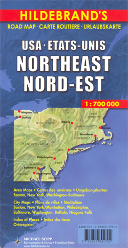
North-eastern USA, with coverage extending from north of Boston to Washington DC and west to the Niagara Falls on an indexed road map at 1:700,000 from Hildebrand, with good presentation of the region’s topography, plus street plans of main cities and/or enlargements for their environs.On one side is a road map of the whole area with main highways and toll routes prominently marked. Connecting secondary routes and local roads have clearly presented road numbers and many show driving distances. Scenic routes are highlighted. Railway lines are included and local airports are marked. The map shows a large number of small towns and indicates county names and boundaries. Relief shading shows the topography, with plenty of names of mountain ranges including smaller mountain chains forming the Appalachian Mountains; national and state parks are prominently highlighted including the Catskills and the southern part of the Adirondacks. Symbols indicate various other places of interest. The map is indexed and has latitude and longitude lines drawn at 30’ intervals. Map legend includes English.Next to the map and on the reverse are insets with street plans highlighting main places of interest and/or enlargements showing environs of main cities: central Boston plus a road map of its environs, a large plan of Manhattan plus environs of NYC including access to the Newark International Airport, downtown Washington DC and Baltimore with a road map of their environs, plus street plans of central Pittsburgh, Philadelphia, Buffalo and Niagara Falls (US side only),

Related Products:
 Argentina North & Uruguay ITMB
 Bangladesh & India East ITMB
 India North East & Kolkata / Calcutta ITMB
 Buenos Aires & Argentina North East ITMB
 Colombia ITMB
 Italy North East Michelin Regional 562
 Germany North Marco Polo Zoom Map
 Japan North & Hokkaido ITMB
 Sydney & Australia East ITMB
 Hanoi – Vietnam North ITMB
 Europe Borch
 Sao Paulo & Brazil South Coast ITMB
 Argentina North – Uruguay Nelles
Sri Lanka & India South ITMB
Argentina North – Uruguay Nelles
Sri Lanka & India South ITMB
 China North East Nelles Map
 Central America Nelles
 Santiago & Chile North ITMB
 Florida F&B
 Ireland Marco Polo Map
 Bulgaria Cartographia Road Map
 Auckland & North Island ITMB
 Java – Jakarta Nelles
 USA East Marco Polo Map
 Beijing Borch
 Lima & Central Peru ITMB
 Tunisia Nelles Map
 Italy North K+F Road Map
 Peru ITMB
 New Zealand Nelles
Kenya – Serengeti Nelles
New Zealand Nelles
Kenya – Serengeti Nelles
 Philippines – Manila Nelles
 Middle East ITMB Travel Atlas
 Osaka & Western Japan ITMB
 Lisbon Borch
 India North Borch
 Mozambique Pocket Map
North Island – New Zealand Hema
Mozambique Pocket Map
North Island – New Zealand Hema
 Latvia Jana Seta Road Atlas