Disclosure : This site contains affiliate links to products. We may receive a commission for purchases made through these links.
Upper Batley 1906
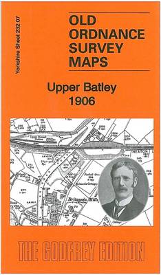
Upper Batley in 1906 in a fascinating series of reproductions of old Ordnance Survey plans in the Alan Godfrey Editions, ideal for anyone interested in the history of their neighbourhood or family. The map covers the northern part of Batley, including part of Upper Batley and Carlinghow, the eastern part of Birstall, and Howden Clough. Features include GNR railway with Howden Clough and Upper Batley stations, West End Colliery, Birkby Brow Colliery, Howley Dye Works, Boggard Fields, part of LNWR Birstall Branch, tramway, Batley Hall, Wensleydale Mills, Brookroyd, Brownhill, Woodlands, Birstall Methodist Chapel, Britannia Mills, Upper Birstall station, Copley Hill, Gelderd Road Quarry, etc. An 1897 timetable for the Birstall Branch is on the reverse. About the Alan Godfrey Editions of the 25″ OS Series:Selected towns in Great Britain and Ireland are covered by maps showing the extent of urban development in the last decades of the 19th and early 20th century. The plans have been taken from the Ordnance Survey mapping and reprinted at about 15 inches to one mile (1:4,340). On the reverse most maps have historical notes and many also include extracts from contemporary directories. Most maps cover about one mile (1.6kms) north/south, one and a half miles (2.4kms) across; adjoining sheets can be combined to provide wider coverage.FOR MORE INFORMATION AND A COMPLETE LIST OF ALL AVAILABLE TITLES PLEASE CLICK ON THE SERIES LINK.

Related Products:
 Staincliffe and Batley Carr 1892
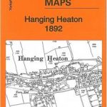 Hanging Heaton 1892
 Upper Edmonton 1894 – 3a
 Hurst and North Ashton 1906
 Peebles 1906 – 13.06
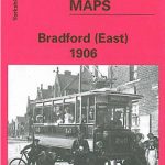 Bradford East 1906
Marsden 1904
Hindley Green 1906
Bradford East 1906
Marsden 1904
Hindley Green 1906
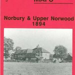 Norbury and Upper Norwood 1894
 Penryn 1906
 Upper Sydenham 1894 – 137.2
 Lisnaskea, Newtownbutler and The Upper Erne 1900
Bamfurlong and Bryn Gates 1906
Langley Moor and Brandon Colliery 1897
Lisnaskea, Newtownbutler and The Upper Erne 1900
Bamfurlong and Bryn Gates 1906
Langley Moor and Brandon Colliery 1897
 Bradford Central 1906
 East Bierley 1905
Pontnewynydd 1899
Earlestown South 1906
East Bierley 1905
Pontnewynydd 1899
Earlestown South 1906
 Rainhill 1906
New Broughton and Stansty Hall 1909
Rainhill 1906
New Broughton and Stansty Hall 1909
 Upper Holloway 1869
Upper Holloway 1894 – 29.2
Upper Holloway 1869
Upper Holloway 1894 – 29.2
 Ebbw Vale (South) 1899 – 11.14
 Heckmondwike 1905
Wadebridge 1906
Bodmin 1906
Drumsagard Hallside & Newton 1896 – 11.06
Moss Valley and Gwersyllt 1909
Pelton and Urpeth 1895
Heckmondwike 1905
Wadebridge 1906
Bodmin 1906
Drumsagard Hallside & Newton 1896 – 11.06
Moss Valley and Gwersyllt 1909
Pelton and Urpeth 1895
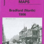 Bradford North 1906
 Crystal Palace, Anerley and Upper Norwood 1894 – 145
Holytown & New Stevenston 1910 – 12.06
Crystal Palace, Anerley and Upper Norwood 1894 – 145
Holytown & New Stevenston 1910 – 12.06
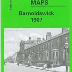 Barnoldswick 1907
Helston 1906
Wakefield West 1905
Newton-le-Willows 1906
Shut End and Tansey Green 1903
Trimdon Grange 1914
Barnoldswick 1907
Helston 1906
Wakefield West 1905
Newton-le-Willows 1906
Shut End and Tansey Green 1903
Trimdon Grange 1914
 St Ives 1906
Leadgate 1895 – 11.11a
St Ives 1906
Leadgate 1895 – 11.11a