Disclosure : This site contains affiliate links to products. We may receive a commission for purchases made through these links.
Upper Austria – Salzkammergut
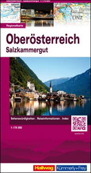
Austrian province of Upper Austria on an indexed, double-sided touring map at 1:175,000 from Hallwag Kรผmmerly + Frey, printed on durable, waterproof and tear-resistant synthetic paper. Coverage, with generous overlap between the sides, includes Salzburg and the Salzkammergut, extending from the Berchtesgaden Alps in Germany to beyond the Gesรคuse National Park and from the heritage Czech town of Ceskรฝ Krumlov to the Alpine resorts of Zee an See, Sankt Johann, Schladming, etc.Clear and easy to read road network highlights scenic roads and indicates motorway junction numbers and services, steep gradients and winter closures, roads not recommended to or closed to caravans, etc. Driving distances are marked on main and on most connecting local routes. Railway lines are shown with stations and include heritage tourist routes. Various places of interest are highlighted. The map also indicates campsites and youth hostels. Topography is presented by light, unobtrusive relief shading with plenty of names of mountain ranges, etc, plus colouring for woodlands and boundaries of national/natural parks. The map is indexed and has latitude and longitude lines at intervals of 10’. Map legend includes English.To see other maps in this series please click on the series link.

Related Products:
 Upper Austria F&B Top 10 Tips
 Austria: Hallwag K+F 175K Regional Maps
 Austria F&B Roads & Cities Atlas
 Upper Austria F&B
 Austria Railway Atlas
 Lower Austria F&B Top 10 Tips
 Bavaria South – Munich – Upper Bavaria K+F Road Map 8
 Vorarlberg – Tyrol K+F Road Map
 Austria F&B 3-Map Set
 Austria F&B Road Map Set
Austria: Freytag & Berndt 150K “Top 10 Tips” Road Maps
Austria F&B Road Map Set
Austria: Freytag & Berndt 150K “Top 10 Tips” Road Maps
 Lake Constance F&B Touring Map
 Sweden South Reise Know-How
Galway County
Sweden South Reise Know-How
Galway County
 Saxony – Thuringia – Upper Franconia F&B Road and Leisure Map
 Dzukija National Park
ลฝemaitija National Park
Aukลกtaitijos National Park
Lake Constance F&B Leisure & Panorama
Dzukija National Park
ลฝemaitija National Park
Aukลกtaitijos National Park
Lake Constance F&B Leisure & Panorama
 Slovenia F&B
Curonian Spit National Park
Slovenia F&B
Curonian Spit National Park
 Upper & Lower Dolpo
Kerry County
Upper & Lower Dolpo
Kerry County
 Cork County
 Clare County
 Upper Somme Valley and Estuary: Abbeville – Saint-Valery-sur-Somme
 Lower Austria F&B
 Upper Bavaria – Lower Bavaria – Swabia F&B Road and Leisure Map
 Severn & Upper Thames 110K Sustrnas Cycle Map No. 11
Austria F&B Great Travel Atlas
Severn & Upper Thames 110K Sustrnas Cycle Map No. 11
Austria F&B Great Travel Atlas
 Austria – Liechtenstein – South Tyrol Marco Polo Road Atlas
Anyksciai Regional Park Tourist Map
Austria – Liechtenstein – South Tyrol Marco Polo Road Atlas
Anyksciai Regional Park Tourist Map
 Mayo and Sligo Xploreit Counties Map
Grazute – Sartai Regional Parks Tourist Map
Mayo and Sligo Xploreit Counties Map
Grazute – Sartai Regional Parks Tourist Map
 Slovenia F&B Top 10 Tips
 Upper Mustang
 Central Norway: Trondheim – Mo i Rana
 Upper & Lower Mustang
 Mustang Upper and Lower