Disclosure : This site contains affiliate links to products. We may receive a commission for purchases made through these links.
United Kingdom North BGS Magnetic Anomaly Map
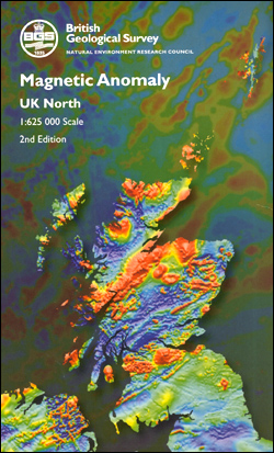
The Magnetic Anomaly Map UK North is a colour contour map that shows variations in the magnetic field over the northern part of the UK landmass and adjacent sea area at a scale of 1: 625, 000. Magnetic contour values are displayed as total field anomaly. Magnetic anomalies show small departures from the expected value of the Earth’s magnetic field caused by variations in the magnetization of the rocks within the crust. The most prominent magnetic anomalies tend to be associated with igneous and metamorphic rocks that are exposed or occur at a shallow depth. The anomaly pattern becomes more subdued where these rocks are more deeply buried.

Related Products:
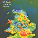 United Kingdom South BGS Magnetic Anomaly Map
 United Kingdom South BGS Gravity Anomaly Map
 Magnetic Fridge Map of the United Kingdom
 United Kingdom North BGS Bedrock Geology Map
 United Kingdom North Bedrock Geology BGS Wall Map
 United Kingdom North BGS Bedrock Geology Pack
 United Kingdom South BGS Bedrock Geology Map
United Kingdom South Bedrock Geology BGS Wall Map
United Kingdom South BGS Bedrock Geology Pack
United Kingdom South BGS Bedrock Geology Map
United Kingdom South Bedrock Geology BGS Wall Map
United Kingdom South BGS Bedrock Geology Pack
 United Kingdom: BGS Bedrock Geology Maps
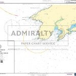
5375 North Atlantic Ocean and Mediterraean Sea – Admiralty Magnetic Variation Chart
World Michelin Wall Map MAGNETIC-BOARD FRAMED
United Kingdom: BGS Bedrock Geology Maps
5375 North Atlantic Ocean and Mediterraean Sea – Admiralty Magnetic Variation Chart
World Michelin Wall Map MAGNETIC-BOARD FRAMED
 Magnetic Field: The Marsden Poems
 World nuance magnetic field round 1000 Piece Jigsaw – square box
 The Magnetic North – Travels in the Arctic
 Magnetic North: Conversations with Tomas Venclova
 Future Mapping Company Monochrome Political World Wall Map MAGNETIC
 World Global Mapping Magnetic Fridge Map
 Magnetic World Map on Fiberboard
 Tunisia: An Arab Anomaly
5374 The World – Admiralty Magnetic Variation Chart
5376 South Atlantic Ocean – Admiralty Magnetic Variation Chart
5399 South Pacific Ocean – Admiralty Magnetic Variation Chart
ADMIRALTY Magnetic Variation Charts
Tunisia: An Arab Anomaly
5374 The World – Admiralty Magnetic Variation Chart
5376 South Atlantic Ocean – Admiralty Magnetic Variation Chart
5399 South Pacific Ocean – Admiralty Magnetic Variation Chart
ADMIRALTY Magnetic Variation Charts
 The BFG Magnetic Bookmark
 Magnetic Travel Snakes & Ladders
 Magnetic Play Pirates
 Endangered African Mammals Magnetic Bookmarks
 Endangered American Animals Magnetic Bookmarks
5383 The World – Admiralty Magnetic Dip Chart
Endangered American Animals Magnetic Bookmarks
5383 The World – Admiralty Magnetic Dip Chart
 World Maps International Political Wall Map SMALL MAGNETIC-BOARD FRAMED with flags
 World Maps International Political Wall Map MEDIUM MAGNETIC-BOARD FRAMED with flags
 World Maps International Political Wall Map X-LARGE MAGNETIC-BOARD FRAMED
 Magnetic Play Vehicles
5385 Indian Ocean – Admiralty Magnetic Variation Chart
Magnetic Play Vehicles
5385 Indian Ocean – Admiralty Magnetic Variation Chart
 World K+F Physical 30M Wall Map MEDIUM MAGNETIC-BOARD
 Magnetic Travel Ludo
 World Maps International Political Wall Map SMALL MAGNETIC-BOARD FRAMED without flags
 World Maps International Political Wall Map LARGE MAGNETIC-BOARD FRAMED without flags
 World Maps International Political Wall Map LARGE MAGNETIC-BOARD FRAMED with flags