Disclosure : This site contains affiliate links to products. We may receive a commission for purchases made through these links.
Turkey`s Highest Peaks – Mount Ararat – Kackar Mountains – Mount Suphan terraQuest Trekking Map
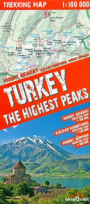
Three of Turkey’s most popular trekking regions: Mount Ararat, Kaรงkar Mountains and Mount Sรผpan on a durable, waterproof and tear-resistant map from terraQuest, plus an overview road map of the eastern part of the country. On one side is a map the Kaรงkar Mountains at 1:120,000 covering an area from Ipsir to Artvin and northwards to Ikizdere and Murgul, with both the Kaรงkar Mountains National Park including the Verรงenik group and the Altiparmak group. The map shows plenty of names of peaks, mountain groups and other topographic features.On the reverse three separate panel show: Mount Ararat National Park at 1:100,000 including Igdir and Dogubayazit; Mount Sรผpan on the northern shore of Lake Van, also at 1:100,000; plus an overview road map of Turkey east of Ankara and Konya.The 1:100,000/120,000 maps have contours at 50m intervals enhanced by relief shading, plus colouring and/or graphics to indicate different types of terrain and vegetation. Trekking routes are prominently highlighted and symbols indicate locations of hotels, pensions, bivouac sites, restaurants, medical services, bus services, various places of interest (including a reconstruction of Noah’s Arc), etc. All the panels have latitude and longitude grid at intervals of 1’. Multilingual map legend includes English.The road map of eastern Turkey at 1:2,500,000 has altitude colouring with plenty of names of topographic features. Driving distances are shown on main roads. Interesting locations, including the various sites in Cappadocia, are prominently highlighted and areas covered by the three detailed panels are also marked. The map has latitude/longitude grid at 1ยฐ intervals.The map is laminated in a format similar to the old cloth-dissected maps so that sections of it can be easily folded back without damage.

Related Products:
 Africa`s Highest Peaks – Kilimanjaro – Mount Kenya – Rwenzori terraQuest Trekking Map
 The Kackar – Trekking in Turkey`s Black Sea Mountains
 Georgian Caucasus – Mt Ushba – Shkhara – Kazbek terraQuest Trekking Map
 Tian Shan – Khan Tengri – Pobeda Peak – Lenin Peak terraQuest Trekking Map
 Indian Himalaya terraQuest Trekking Map
 Tibet – Mount Everest – Nam Tso – Lhasa – Shigatse terraQuest Tourist Map
 Kackar – Altiparmak Mountains
 Karakoram – K2 – Gasherbrum – Broad Peak terraQuest Trekking Map
 Tilting at Mountains: Overcoming Personal Demons to Climb the World`s Highest Peaks
 Fagaras – Bucegi – Piatra Craiului terraQuest Trekking Map
 Aconcagua terraQuest Trekking Map
 Turkey & West Turkey
 Prokletije – Durmitor – Albanian and Montenegro Alps terraQuest Trekking Map
Georgia – Caucasus Mountains terraQuest Adventure Map
Prokletije – Durmitor – Albanian and Montenegro Alps terraQuest Trekking Map
Georgia – Caucasus Mountains terraQuest Adventure Map
 Madeira terraQuest Trekking Map
 Lake Como terraQuest Trekking Map
 Patagonia – Fitz Roy – Cerro Torre – Perito Moreno Glac – Torres del Paine terraQuest Trekking Map
 Mount Pelion – Mount Mavrovouni Anavasi 4.3/4.4
 Aladaglar Mountains – Turkey
 Mount Olympos Region – Eastern Lycia
 The Mountains of Romania: Trekking in the Carpathian Mountains
 Hiking and Trekking in the Japan Alps and Mount Fuji: Northern, Central and Southern Alps
 Lake Garda terraQuest Trekking Map
 Mount Shasta Wilderness
 Turkey Reise Know-How
 Central Pyrenees terraQuest Trekking Map
 Rila – Pirin terraQuest Trekking Map
 Mount Elgon
 Bhutan Himalaya Trekking Map
 Mount Makalu
 Turkey F&B
 High Atlas – Jbel – Toubkal terraQuest Trekking Map
 Turkey Michelin
 Turkey Flexi Map
 Wilderness Trekking in Oman: 200km Traverse of the Western Hajar Mountains
 Mount Everest 1938: Whether These Mountains are Climbed or Not, Smaller Expeditions are a Step in the Right Direction
 Istanbul & Northwest Turkey ITMB
 Morocco: Atlas Mountains Topographic Maps
 Mount Athos