Disclosure : This site contains affiliate links to products. We may receive a commission for purchases made through these links.
Turkey ITMB
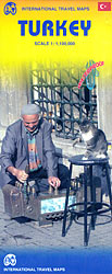
Turkey on an indexed road map at 1:1,100,000 from ITMB printed on light, waterproof and tear-resistant synthetic paper; an inset provides a street plan of the old historic part of Istanbul with the city’s main tourist sights. The map is double-sided, with a small overlap between the sides. Most of the Mediterranean coastline is covered on the western half of the map, but the main sights of Cappadocia are rather inconveniently split between the two sides.Topography is shown by altitude colouring in feet, with peak heights given in metres, plus names of mountain ranges. Road network includes selected local tracks, gives distances on main routes and shows border crossings. Railway lines and local airports are included and along the Aegean and the Sea of Marmara ferry routes are marked. A range of symbols indicate various places of interest, including UNESCO World Heritage sites, archaeological remains, etc. The map has latitude and longitude grid at intervals of 1ยฐ and a separate index of localities for each side.Also provided is an inset showing the old historic part of Istanbul south of the Golden Horn, extending west to the Yenicapi station, so well beyond the Grand Bazaar, the University and the Kumkapi area. Main sights are highlighted and the tram line is shown with stops.

Related Products:
 Istanbul & Northwest Turkey ITMB
 Turkey South Coast ITMB
 Turkey Michelin
 Turkey & West Turkey
 Turkey Reise Know-How
 Turkey Flexi Map
 Turkey F&B
 Greece ITMB
 Sweden South Reise Know-How
 Turkey Central – Cappadocia ITMB
 Turkey – Europe Road Map
 Turkey – Middle East Road Map
 Cuba West ITMB
 Czech Republic Road Atlas
 Oman Map & Guide
 Turkey from the Air
 Czech Republic ITMB
 Iraq & Baghdad ITMB
 Mexico Michelin
 South America ITMB
 Turkey Marco Polo Map
 Mexico ITMB
 Kenya ITMB
 Uganda ITMB
 Mexico Reise Know-How
 Morocco Reise Know-How
 Riga ITMB
 Hanoi – Vietnam North ITMB
 Istanbul Mepmedya Tourist Plan
 Egypt Reise Know-How
 Ecuador – Galapagos NGS Adventure Map 3403
 Bahrain and Manama City ITMB
 Latvia & Riga ITMB
 Fodor`s Essential Turkey
 Turkey`s Highest Peaks – Mount Ararat – Kackar Mountains – Mount Suphan terraQuest Trekking Map
 Berlitz Pocket Guide Turkey (Travel Guide with Dictionary)
 Madagascar F&B
 Armenia Reise Know-How
 Estonia & Tallinn ITMB
 Europe Railway & Road ITMB