Disclosure : This site contains affiliate links to products. We may receive a commission for purchases made through these links.
Trucker`s Britain Philip`s Road Atlas A3 SPIRAL-BOUND
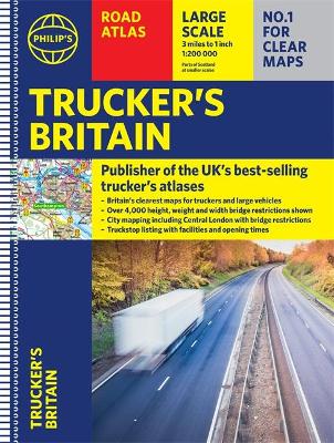
PHILIP`S – THE ATLAS BRAND FOR TRUCKERS, CARAVANNERS AND OTHER SERIOUS ROAD USERSโ€The best of its kind with quick and easy to use informationโ€ Fleet Week- Essential for Truckers (and very useful for Caravanners too)- Over 4,000 bridges with restrictions – either height, weight or width – located on the maps- Super-clear maps of the UK at 1:200,000 (Northern Scotland 1:250,000)- Special Feature: โ€Bridge Strikesโ€ (including โ€Most Hit Bridgesโ€, numbering approximately 50, which includes all bridges struck five or more time in a 12-month period- Lists Restricted Motorway Junctions with explanations – Truck stop listings and location maps, including the facilities and opening times- Big format and spiral binding – easy-to-use on the road- 12 pages of urban area maps with bridge restrictions- Central London maps – with bridge restrictions`Even though I have a satnav I find a map essential for planning in stops on long routes.` a trucker customer

Related Products:
 Britain Philip`s Navigator Trucker`s Road Atlas A3 SPIRAL-BOUND
 Britain AA Trucker`s Atlas A3 SPIRAL-BOUND
 Britain & Ireland Philip`s Complete Road Atlas 2017 SPIRAL-BOUND
 Britain & Ireland Philip`s Road Atlas 2022 A4 SPIRAL-BOUND
 Britain & Ireland Philip`s Complete Road Atlas 2020 SPIRAL-BOUND
 Britain Philip`s Navigator Road Atlas SPIRAL-BOUND
 Britain & Ireland Philip`s Handy Road Atlas A5 SPIRAL-BOUND
 Britain Philip`s Big Easy to Read Road Atlas 2022 A3 SPIRAL-BOUND
 France Philip`s Navigator Road Atlas SPIRAL-BOUND
 Britain Philip`s Navigator Easy-Use Road Atlas SPIRAL-BOUND
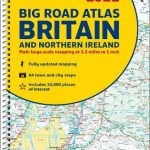
 Britain and Northern Ireland Collins Big Road Atlas 2023 A3 SPIRAL-BOUND
 Britain & Ireland Philip`s Big Road Atlas 2022 A3 SPRIAL-BOUND
 Europe Philip`s Multiscale Road Atlas 2021 A4 SPIRAL-BOUND
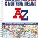
 Great Britain A-Z Road Atlas 2022 A4 SPIRAL-BOUND
 Britain and Northern Ireland Collins Big Road Atlas 2022 A3 SPIRAL-BOUND
 Britain Philip`s Navigator Road Atlas FLEXI-BOUND
Great Britain A-Z Road Atlas 2023 A4 SPIRAL-BOUND
Britain Philip`s Navigator Road Atlas FLEXI-BOUND
Great Britain A-Z Road Atlas 2023 A4 SPIRAL-BOUND
 Britain & Ireland Philip`s Big Road Atlas 2017
Britain and Northern Ireland Collins Essential Road Atlas 2022 A4 SPIRAL-BOUND
Britain & Ireland Philip`s Big Road Atlas 2017
Britain and Northern Ireland Collins Essential Road Atlas 2022 A4 SPIRAL-BOUND
 Britain & Ireland Philip`s Essential Road Atlas 2021 A4 PAPERBACK
 Great Britain & Northern Ireland A-Z Super Scale Road Atlas 2022 A3 SPIRAL-BOUND
Great Britain & Northern Ireland A-Z Super Scale Road Atlas 2023 A3 SPIRAL-BOUND
Great Britain & Northern Ireland A-Z Super Scale Road Atlas 2022 A3 SPIRAL-BOUND
Great Britain & Northern Ireland A-Z Super Scale Road Atlas 2023 A3 SPIRAL-BOUND
 Britain Philip`s Navigator Camping and Caravanning Road Atlas
 Great Britain A-Z Handy Road Atlas 2022 A5 SPIRAL-BOUND
 Britain and Ireland Philip`s Road Atlas 2022 A4 PAPERBACK
 Hungary Pocket Road Atlas SPIRAL-BOUND
 Britain & Ireland Philip`s Big Road Atlas 2021 A3 PAPERBACK
 Britain & Ireland Philip`s Motorist`s Road Atlas 2019 A3 PAPERBACK
Britain and Ireland Collins Handy Road Atlas 2023 A5 SPIRAL-BOUND
Britain & Ireland Philip`s Motorist`s Road Atlas 2019 A3 PAPERBACK
Britain and Ireland Collins Handy Road Atlas 2023 A5 SPIRAL-BOUND
 Britain & Ireland Philip`s Complete Road Atlas 2020 HARDBACK
 Britain & Ireland Philip`s Big Road Atlas 2022 A3 PAPERBACK
 Britain Philip`s Driver`s Road Atlas A4 PAPERBACK
Great Britain A-Z Handy Road Atlas 2023 A5 SPIRAL-BOUND
Britain Philip`s Driver`s Road Atlas A4 PAPERBACK
Great Britain A-Z Handy Road Atlas 2023 A5 SPIRAL-BOUND
 Britain and Ireland Collins Handy Road Atlas 2022 A5 SPIRAL-BOUND
 Britain and Ireland Collins Handy Road Atlas 2021 A5 SPIRAL-BOUND
 France & Spain Philip`s Road Atlas
 Europe Collins Essential Road Atlas A4 SPIRAL-BOUND
 Great Britain: A-Z Road Atlas 2015 – A4, SPIRAL BOUND SUPERSEDED
 Britain Philip`s Navigator Easy-Use Road Atlas
 Britain AA Road Atlas 2022 A4 SPIRAL-BOUND