Disclosure : This site contains affiliate links to products. We may receive a commission for purchases made through these links.
Trinidad & Tobago ITMB
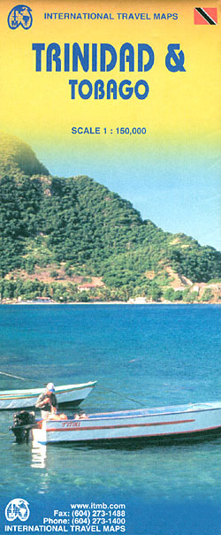
Tobago and Trinidad at 1:150,000 indexed, clear road map from ITMB with additional topographic and tourist information.Road networks include motorways, primary and secondary roads and tracks, with intermediate distances in kilometres on expressways, main and secondary roads. Symbols clearly indicate petrol stations and airports; railways and ferry routes are shown. Topography is represented by altitude colouring and graphics indicate rivers, marshes, coral reef, caves, volcanoes, etc. Spot heights are marked and mountain ranges named. Symbols mark locations of various places of interest including camping sites, nature reserves, botanical gardens, zoos, archeologically sites, golf courses, beach and diving spots, ports, etc. Administrative boundaries are marked and provinces named. The map is indexed and annotated with historical and tourist information of places of interest.Latitude and longitude line are drawn at intervals of 5’.

Related Products:
 Trinidad and Tobago Reise Know-How
 Trinidad & Tobago F&B
 Trinidad and Tobago Collins School Atlas
 Trinidad and Tobago Footprint Handbook
 Enchanting Trinidad & Tobago
 Libya – Tunisia ITMB
 Birds of Trinidad and Tobago: Third Edition
 The Rough Guide to Trinidad and Tobago
 B6 Trinidad and Tobago
 Trinidad and Tobago Dive Guide
New Zealand ITMB
Trinidad and Tobago Dive Guide
New Zealand ITMB
 Rome & Southern Italy ITMB
 Iraq & Baghdad ITMB
 Philippines ITMB
 Cruising Guide to Trinidad and Tobago, plus Barbados and Guyana
 Trinidad and Tobago Flag – 1/2 yard – Printed
 Trinidad & Tobago – Culture Smart!
 Flag of Trinidad & Tobago – Small 3ft x 2ft
 Estonia & Tallinn ITMB
 Iceland ITMB
 Trinidad and Tobago
 Reykjavik & SW Iceland ITMB
 Pakistan ITMB
 Birdwatchers Guide to Trinidad and Tobago
 Alberta ITMB
 Ghana ITMB
 St. Martin & Anguilla ITMB
Brazil ITMB
St. Martin & Anguilla ITMB
Brazil ITMB
 Bhutan Reise Know-How
 Panama ITMB
 Philadelphia & Mid-Atlantic States ITMB
 South Africa Giant Road Map
 Mexico Border States: Coahuila, Nuevo Leon, Tamaulipas ITMB
 China ITMB
 China East ITMB
 Bhutan & Northeast India ITMB
 Madagascar ITMB
 Paris & France North ITMB
 Sierra Leone ITMB