Disclosure : This site contains affiliate links to products. We may receive a commission for purchases made through these links.
Trinidad and Tobago Reise Know-How
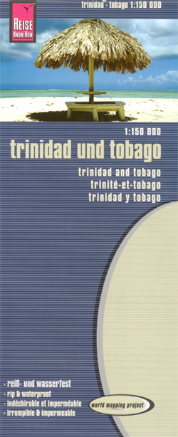
Indexed, waterproof and tear-resistant road map of Trinidad and Tobago with topographic and tourist information, published by Reise Know-How as part of their highly acclaimed World Mapping Project. Topography is presented by altitude colouring with contours. Swamps and coral reefs are marked. Road network includes unsurfaced local roads and tracks, and indicates driving distances on main and secondary roads and locations of petrol stations. Where appropriate road names are shown, Ferry connections between the two islands and with Venezuela are also indicated. Symbols highlight various places of interest, including wildlife sanctuaries and forest reserves, botanical gardens, viewpoints, golf courses, beaches, diving and surfing sites, yacht harbours, etc. The map has both a UTM grid and a latitude and longitude grid at intervals of 10’, plus an index of localities. Map legend includes English.*”World Mapping Project”* is an extensive series of maps at varying scales, aiming to provide coverage of countries and regions worldwide using clear, well presented cartography with both topographic and tourist information.

Related Products:
 Venezuela Reise-Know-How Map
 Trinidad & Tobago ITMB
 Algarve Reise Know-How
 Nicaragua – Honduras – El Salvador Reise Know-How
 Costa Rica Reise Know-How
 Costa Rica – Panama Reise Know-How
 Corfu Reise Know-How
 Jamaica Reise Know-How
 Istria Reise Know-How
 Yucatan Reise Know-How
 Philippines Reise Know-How
 Taiwan Reise Know-How
Uganda Reise Know-How
Taiwan Reise Know-How
Uganda Reise Know-How
 Tanzania Reise Know-How
 Hungary Reise Know-How
 Rhodes Reise-Know-How
 Ecuador – Galapagos Islands Reise Know-How
 Afghanistan Reise-Know-How Map
 Oman Reise Know-How
 Ghana – Togo Reise Know-How
 Central America Reise-Know-How Map
 Dominican Republic – Haiti Reise Know-How
 Czechia Reise Know-How
 Turkey Reise Know-How
 Sri Lanka Reise Know-How
 Africa Southern Reise Know-How
Italy Reise Know-How
Africa Southern Reise Know-How
Italy Reise Know-How
 Albania Reise Know-How
 Pakistan Reise Know-How
 Azores Reise Know-How
 Saudi Arabia Reise Know-How
 Algeria – Tunisia Reise Know-How
 Lithuania Reise Know-How
 Peru Reise Know-How
 Kazakhstan Reise Know-How
 Madagascar Reise Know-How
 Tuscany Reise Know-How
 New Zealand Reise Know-How
 Trinidad & Tobago F&B
 Crimea Reise Know-How