Disclosure : This site contains affiliate links to products. We may receive a commission for purchases made through these links.
Trimdon Grange 1914
Trimdon Grange in 1914 in a fascinating series of reproductions of old Ordnance Survey plans in the Alan Godfrey Editions, ideal for anyone interested in the history of their neighbourhood or family. The map covers two villages, Trimdon Grange, near the centre of the map and much of Trimdon Colliery about half a mile away. Features include Trimdon Grange Colliery, old quarries, Trimdon Colliery (disused), the Ferryhill & East Hartlepool railway, Trimdon station, Deaf Hill, St Paul`s church, etc. The villages are shown in detail, with railway tracks, houses and outhouses. On the reverse is an 1894 directory of Trimdon.About the Alan Godfrey Editions of the 25″ OS Series:Selected towns in Great Britain and Ireland are covered by maps showing the extent of urban development in the last decades of the 19th and early 20th century. The plans have been taken from the Ordnance Survey mapping and reprinted at about 15 inches to one mile (1:4,340). On the reverse most maps have historical notes and many also include extracts from contemporary directories. Most maps cover about one mile (1.6kms) north/south, one and a half miles (2.4kms) across; adjoining sheets can be combined to provide wider coverage.FOR MORE INFORMATION AND A COMPLETE LIST OF ALL AVAILABLE TITLES PLEASE CLICK ON THE SERIES LINK.

Related Products:
 Chigwell Row and Grange Hill 1914
Gurnos 1914 – 43.14
Ryhope Village 1895
Chigwell Row and Grange Hill 1914
Gurnos 1914 – 43.14
Ryhope Village 1895
 Chesterfield 1914 – 25.06b
Llantwit Major 1914
Lye 1914
Chesterfield 1914 – 25.06b
Llantwit Major 1914
Lye 1914
 Coombeswood 1914
Carlton Main & Shafton Two Gates 1914 – 263.13
Langley Moor and Brandon Colliery 1897
Finchfield and Wightwick 1914
Newcastle & Gateshead 1914 – 18b
Wolverhampton Bushbury 1914
Jesmond 1914
Chigwell Station 1914
Coombeswood 1914
Carlton Main & Shafton Two Gates 1914 – 263.13
Langley Moor and Brandon Colliery 1897
Finchfield and Wightwick 1914
Newcastle & Gateshead 1914 – 18b
Wolverhampton Bushbury 1914
Jesmond 1914
Chigwell Station 1914
 New Cross 1914 – 104.3
Pontnewynydd 1899
Pwllheli 1914
Meadowfield 1897
New Cross 1914 – 104.3
Pontnewynydd 1899
Pwllheli 1914
Meadowfield 1897
 Stratford 1914 – 42.3
Drumsagard Hallside & Newton 1896 – 11.06
Shincliffe 1895
Stratford 1914 – 42.3
Drumsagard Hallside & Newton 1896 – 11.06
Shincliffe 1895
 Highbury & Islington 1914 – 39.3
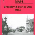 Brockley & Honor Oak 1914 – 118.3
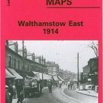 Walthamstow (East) 1914 – 15.3
Sacriston 1897
Motherwell (East) 1897 – 12.14
Hobson and Tantobie 1895
Stourbridge South and Oldswinford 1914
Broomhouse, Daldowie and Haughead 1896
Monk Bretton & Smithies 1904 – 274.04
Walthamstow (East) 1914 – 15.3
Sacriston 1897
Motherwell (East) 1897 – 12.14
Hobson and Tantobie 1895
Stourbridge South and Oldswinford 1914
Broomhouse, Daldowie and Haughead 1896
Monk Bretton & Smithies 1904 – 274.04
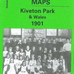 Kiveton Park and Wales 1901
Dipton 1916
Shildon 1896
Stanley 1895
Stanley 1915
Wrexham North 1909
Sandwell Hall 1902
Kiveton Park and Wales 1901
Dipton 1916
Shildon 1896
Stanley 1895
Stanley 1915
Wrexham North 1909
Sandwell Hall 1902
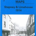 Stepney & Limehouse 1914 – 64.3
Kensington 1914 – 74.3
Hopwood Hall and Thornham 1907
Stepney & Limehouse 1914 – 64.3
Kensington 1914 – 74.3
Hopwood Hall and Thornham 1907