Disclosure : This site contains affiliate links to products. We may receive a commission for purchases made through these links.
Tredegar North 1899
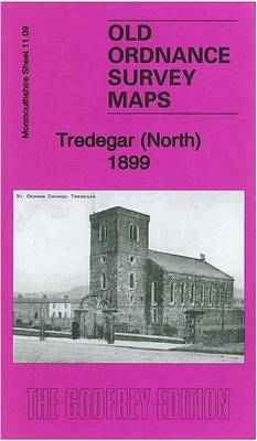
Tredegar North in 1899 in a fascinating series of reproductions of old Ordnance Survey plans in the Alan Godfrey Editions, ideal for anyone interested in the history of their neighbourhood or family. The map covers the northern part of Tredegar, including Sirhowy, stretching from Dukestown and St Luke`s church southward to Commercial Road. Features include north part of Tredegar Iron Works, Gelli Cottages, St George`s church, Beaufort Row, Sirhowy area, Sirhowy Inn, The Four Rows, Dukestown area, Scwrfa area, LNWR Sirhowy Branch with Sirhowy station, numerous mineral lines, old coal pits, old quarries, coke ovens, etc. A 1906 commercial directory of Tredegar is on the reverse. About the Alan Godfrey Editions of the 25″ OS Series:Selected towns in Great Britain and Ireland are covered by maps showing the extent of urban development in the last decades of the 19th and early 20th century. The plans have been taken from the Ordnance Survey mapping and reprinted at about 15 inches to one mile (1:4,340). On the reverse most maps have historical notes and many also include extracts from contemporary directories. Most maps cover about one mile (1.6kms) north/south, one and a half miles (2.4kms) across; adjoining sheets can be combined to provide wider coverage.FOR MORE INFORMATION AND A COMPLETE LIST OF ALL AVAILABLE TITLES PLEASE CLICK ON THE SERIES LINK.

Related Products:
 New Tredegar 1899
 Tredegar South 1899
 Ebbw Vale North 1899
 Dumfries North 1899
Stockton (North) 1899 – 50.12a
Dumfries North 1899
Stockton (North) 1899 – 50.12a
 Knutsford North 1908
Nottingham (Arnold & Daybrook) 1899 – 38.06
Central Nottingham 1899 – 42.02b
Carshalton & North Wallington 1910 – 13.12
Knutsford North 1908
Nottingham (Arnold & Daybrook) 1899 – 38.06
Central Nottingham 1899 – 42.02b
Carshalton & North Wallington 1910 – 13.12
 Hanworth and North West Hampton 1934
 Llandudno (West) 1899 – 1.16
Pontnewynydd 1899
Aberdeen (Bridge of Don) 1899 – 75.03
Llandudno (West) 1899 – 1.16
Pontnewynydd 1899
Aberdeen (Bridge of Don) 1899 – 75.03
 Bromley Common and North-East Hayes 1895
North Shields and Chirton 1894
Bromley Common and North-East Hayes 1895
North Shields and Chirton 1894
 Tottenham (North) 1894 – 8a
Colwyn Bay North 1911
Darlington North 1896
Nottingham (Sherwood) 1899 – 38.10
Wrexham North 1909
North Surbiton and South Kingston 1932
Tottenham (North) 1894 – 8a
Colwyn Bay North 1911
Darlington North 1896
Nottingham (Sherwood) 1899 – 38.10
Wrexham North 1909
North Surbiton and South Kingston 1932
 Ebbw Vale (South) 1899 – 11.14
Nottingham (South) 1899 – 42.06b
Ebbw Vale (South) 1899 – 11.14
Nottingham (South) 1899 – 42.06b
 Bromley North and Sundridge Park 1895
 Croydon North-East 1895
North Chorley 1909 – 77.08
Croydon North-East 1895
North Chorley 1909 – 77.08
 Derby (South) 1899 – 50.13a
Carlisle North-East 1924
Hurst and North Ashton 1906
Derby (South) 1899 – 50.13a
Carlisle North-East 1924
Hurst and North Ashton 1906
 Beverley North 1908
Northfield North 1903
Horwich North 1907
Beverley North 1908
Northfield North 1903
Horwich North 1907
 Cambridge (North) 1901 – 40.14
Glasgow North East 1893
Cambridge (North) 1901 – 40.14
Glasgow North East 1893
 Sevenoaks North and Riverhead 1907
 Warwick North 1923
Southport (North) 1909 – 75.06b
Warwick North 1923
Southport (North) 1909 – 75.06b
 Evesham North 1903
Swindon (NW) 1899 – 15.03a
Swindon (NE) 1899 – 15.04a
Evesham North 1903
Swindon (NW) 1899 – 15.03a
Swindon (NE) 1899 – 15.04a