Disclosure : This site contains affiliate links to products. We may receive a commission for purchases made through these links.
Torsby
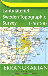
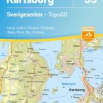
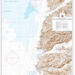
Topographic survey of Sweden at 1:50,000, the Terrรคngkartan, from the Lantmรคteriet, covering most of the country in 244 double-sided maps. Please note: the mountainous regions of central and northern Sweden are not covered by this series but presented in a separate ‘Fjรคllkartan – Mountain Map” series also listed on our website.Each 1:50,000 topographic survey map covers an area of 37.5 x 40km. The maps have contours at 5 metre intervals, plus relief shading and graphics for rocky outcrops and boulders. Further graphics and/or colouring show different types of land use or vegetation (forests, arable land, orchards, marshes, peat bogs, etc). An unusual feature of this survey is the colouring indicating buildings below or above two storeys high and ‘leisure/holiday homes”. The maps indicate privately maintained roads and include all other information expected of topographic survey at this scale. The maps have a 1-km UTM grid, plus latitude and longitude lines 5’ intervals. Map legend includes English.For coverage of the country’s most visited hiking areas in central and northern Sweden please see Lantmรคteriet’s Mountain Map series, listed separately on our website.

Related Products:
 Umeรฅ
Fรฅrรถ
Hjo
Ed
ร…mรฅl
Laxรฅ
Nas
Vรคstervik
Arvika
Falun
Edsbyn
Sรถderhamn
Sundsvall
Norsjรถ
Harads
ร–verum
Mjรถlby
Stendorren
Hallsberg
Vรคrmdรถ
Hรคllefors
Charlottenberg
Uddheden
Gimo
Malung
Sollerรถn
Alvho
Voxna
Delsbo
Njurunda
Gรคllรถ
Kรคlarne
Borgvattnet
Strรถmsund
Backe
Nordmaling
Holmรถn
Piteรฅ
Seskarรถ
Svanstein
Umeรฅ
Fรฅrรถ
Hjo
Ed
ร…mรฅl
Laxรฅ
Nas
Vรคstervik
Arvika
Falun
Edsbyn
Sรถderhamn
Sundsvall
Norsjรถ
Harads
ร–verum
Mjรถlby
Stendorren
Hallsberg
Vรคrmdรถ
Hรคllefors
Charlottenberg
Uddheden
Gimo
Malung
Sollerรถn
Alvho
Voxna
Delsbo
Njurunda
Gรคllรถ
Kรคlarne
Borgvattnet
Strรถmsund
Backe
Nordmaling
Holmรถn
Piteรฅ
Seskarรถ
Svanstein