Disclosure : This site contains affiliate links to products. We may receive a commission for purchases made through these links.
Torres del Paine – Puerto Natales and Environs
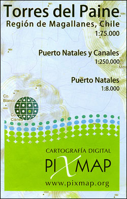
Torres del Paine at 1:75,000 with hiking trails and route profiles on a GPS compatible, contoured map from Piximap, plus on the reverse the fjords west of Puerto Natales at 1:250,000 and a street plan of the town.On one side is the central area of the Torres del Paine National Park, extending from Posada Rio Serrano on the north-western tip of Lago del Torres northwards across the Paine massif to Lago Dickson, plus eastwards to include ranger stations, huts and camping areas around Lago Azul and Lago Verde. The map provides a very clear picture of the region’s terrain through contours at 25m intervals enhanced by relief shading and colouring for forests, grassland, swamps and glaciers, plus plenty of names of topographic features.Roads are classified as dirt or 4×4/AWD; hiking trails distinguish between main routes and those without waymarking. Symbols indicate locations of campsites and camping areas, huts and ranger stations, viewpoints, etc, as well as facilities available in Posada Rio Serrano. The map has latitude and longitude lines at 5’ plus UTM margin ticks. On the reverse 10 routes are shown on profiles indicating distances and changes in altitude.The reverse side provides a map at 1:250,000 of the region south of Posada Rio Serrano and west of Puerto Natales, criss-crossed by numerous fjords, also with contours and locations of piers for marine navigation. Latitude/longitude lines are at 10’ with additional UTM margin ticks. Also included here is a street plan of Puerto Natales shown locations of various facilities.Map legend for the main map includes English; the plan of Puerto Natales has a self-explanatory Spanish legend only.

Related Products:
 Torres del Paine – Puerto Natales – Sierra Baguales SIG Patagon
 Torres del Paine 50K/100K Trekkingchile Map
 Torres del Paine Trekking Map
 Campos de Hielo – Torres del Paine
 Torres del Paine: Chile`s Premier National Park and Argentina`s Los Glaciares National Park
 Patagonia – Fitz Roy – Cerro Torre – Perito Moreno Glac – Torres del Paine terraQuest Trekking Map
 Torres Novas
 Torres Vedras
 El Chaten – El Calafate de Dios Regional Map
 Lake Llanquihue and Surrounding Region
 Puerto Rico NGS Adventure Map 3107
 Lucainena de la Torres CNIG Topo 1030-4
Torres De Albarracin CNIG Topographic Map 565-II
Lucainena de la Torres CNIG Topo 1030-4
Torres De Albarracin CNIG Topographic Map 565-II
 Puerto Vallarta
Puerto Escondido
Puerto Penasco
Puerto Vallarta
Puerto Escondido
Puerto Penasco
 NOAA Chart 25668 – North Coast of Puerto Rico’”Punta Peรฑon to Punta Vacia Talega – Puerto Arecibo – Puerto Palmas Altas
 Madrigal de las Altas Torres CNIG Topo 454
 Tbilisi and Environs Geoland Street Plan WATERPROOF
 Tierra del Fuego – Cordillera Darwin – Lago Fagnano – Isla Navarino SIG Patagon
Tbilisi and Environs Geoland Street Plan
Tierra del Fuego – Cordillera Darwin – Lago Fagnano – Isla Navarino SIG Patagon
Tbilisi and Environs Geoland Street Plan
 Burgos and Environs CNIG Map
 NGA Chart 21489 – Approaches to Puerto San Jose and Puerto Quetzal
 NGA Chart 28165 – Puerto Santo Tomas de Castilla and Puerto Barrios
 Puerto de la Cruz CNIG Topo 1092
Puerto Rico CNIG Topo 1106
Puerto del Rosario CNIG Topo 1090
Puerto de la Cruz CNIG Topo 1092
Puerto Rico CNIG Topo 1106
Puerto del Rosario CNIG Topo 1090
 Volcรกn Villarrica – Lago Caburgua
 Admiralty Chart 1863 – Puerto de los Marmoles to Puerto del Rosario
 Admiralty Chart 3334 – Puerto Deseado To Puerto Santa Cruz
 Passage Planning Guide : Great Barrier Reef and Torres Strait 2019
 Puerto del Rosario CNIG Topo 1090-4
Puerto de la Cruz CNIG Topo 1092-1
Felipe Carrillo Puerto
Puerto del Rosario CNIG Topo 1090-4
Puerto de la Cruz CNIG Topo 1092-1
Felipe Carrillo Puerto
 Santiago Environs
El Puerto de Santa Maria CNIG Topo 1061-2
Santiago Environs
El Puerto de Santa Maria CNIG Topo 1061-2
 Chile – Patagonia Nelles
 Argentina South & Tierra del Fuego ITMB
 Caribbean National Forest – Puerto Rico NGS Trails Illustrated Map 790
 Patagonia & Tierra del Fuego ITMB