Disclosure : This site contains affiliate links to products. We may receive a commission for purchases made through these links.
Titanic Reference NGS Wall Map PAPER
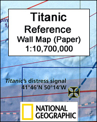
Titanic Reference Wall Map from the National Geographic, paper version ‘“ size 99 x 66cm (39″ x 26″), presenting on one side a map of the Atlantic annotated with shipping routes, sea currents, iceberg lines, etc, plus very extensive text on all aspects relating to the sinking of the ship; on the reverse is more information about the ship itself plus notes about the lost and the saved, the legacy of the disaster, and more.On one side the map shows the route of the Titanic from Southampton, via Cherbourg in France and Queenstown (now Cobh) in Ireland, to the point where the ship issued its distress signal, together with shipping lanes before and after 1913, as well as sights of notable shipwrecks and landmarks. On land, on both sides of the Atlantic, the map shows locations of various institutions and memorials connected with the Titanic. The map of the Atlantic is surrounded by several panels providing further information: Icebergs, Shipping News, Women and Children First, In Memoriam, and The Wreck Discovered ‘“ illustrated with a more detailed map of the area and colour photos. Also included is a graph showing iceberg frequency, a table with a breakdown of losses among passengers and the crew of the ship, time chart from commissioning the design of the Titanic to the death of the last survivor in 2009, etc.On the reverse, are detailed drawings of the ship’s decks and the ships’ profile, information about selected victims and survivors, comparisons of its size with other famous ships and buildings, a list of films, plays and documentaries inspired by the disaster, etc.This map is also available encapsulated and in a folded format.

Related Products:
 Titanic Reference NGS Wall Map ENCAPSULATED
 Titanic Reference Map
 Titanic Lives
 Shadow of the Titanic: The Extraordinary Stories of Those Who Survived
 Down With The Old Canoe: Cultural History Of The Titanic Disaster
 The Midnight Watch: A Gripping Novel of the SS Californian, the Ship That Failed to Aid the Sinking Titanic
Rescuing Titanic: A True Story of Quiet Bravery in the North Atlantic
The Midnight Watch: A Gripping Novel of the SS Californian, the Ship That Failed to Aid the Sinking Titanic
Rescuing Titanic: A True Story of Quiet Bravery in the North Atlantic
 The Story of the Titanic for Children
 Titanic: First Accounts
 Lost Voices from the “Titanic”: The Definitive Oral History
 American War of Independence – War of 1812 NGS NGS Wall Map PAPER
 Titanic
 Titanic Sticker Book
 Titanic: A Passenger`s Guide Pocket Book
 Captain of the Carpathia: The seafaring life of Titanic hero Sir Arthur Henry Rostron
 Olympic, Titanic, Britannic
 Transatlantic Liners
 The Girl Who Came Home: A Novel of the Titanic
 Exploring the Britannic: The life, last voyage and wreck of Titanic`s tragic twin
 Disaster at Sea
 Titanic in Photographs
 SS Nomadic: Titanic`s Little Sister
 Story of the Titanic
 American War of Independence – War of 1812 NGS NGS Wall Map ENCAPSULATED
 The Earth`s Moon NGS Wall Map PAPER
 Stanford`s Library Map of London Sheet 10 Black and White (1862) – A4 Wall Map, Paper
Stanford`s Library Map of London Sheet 10 Black and White (1862) – A2 Wall Map, Paper
Stanford`s Library Map of London Sheet 10 Black and White (1862) – A1 Wall Map, Paper
Stanford`s Library Map of London Sheet 10 Black and White (1862) – A4 Wall Map, Paper
Stanford`s Library Map of London Sheet 10 Black and White (1862) – A2 Wall Map, Paper
Stanford`s Library Map of London Sheet 10 Black and White (1862) – A1 Wall Map, Paper
 Stanford`s Library Map of London Sheet 10 Colour (1862) – A4 Wall Map, Paper
Stanford`s Library Map of London Sheet 10 Colour (1862) – A3 Wall Map, Paper
Stanford`s Library Map of London Sheet 10 Colour (1862) – A2 Wall Map, Paper
Stanford`s Library Map of London Sheet 10 Colour (1862) – A1 Wall Map, Paper
Stanford`s Library Map of London Sheet 10 Colour (1862) – A4 Wall Map, Paper
Stanford`s Library Map of London Sheet 10 Colour (1862) – A3 Wall Map, Paper
Stanford`s Library Map of London Sheet 10 Colour (1862) – A2 Wall Map, Paper
Stanford`s Library Map of London Sheet 10 Colour (1862) – A1 Wall Map, Paper
 Stanford`s Library Map of the World (1879) – A3 Wall Map, Paper
 A Night to Remember
 Africa NGS Executive Wall Map PAPER
 U.S. College and University Professor Pathfinder`s Reference Map
 Titanic: Minute by Minute
 Maine Raven Maps Physical Wall Map PAPER
 Pearl Harbor Then and Now Historical Map
Stanford`s Library Map of London Sheet 10 Black and White (1862) – A3 Wall Map, Paper – Print on Demand
Pearl Harbor Then and Now Historical Map
Stanford`s Library Map of London Sheet 10 Black and White (1862) – A3 Wall Map, Paper – Print on Demand