Disclosure : This site contains affiliate links to products. We may receive a commission for purchases made through these links.
Tierra del Fuego Historical Maps
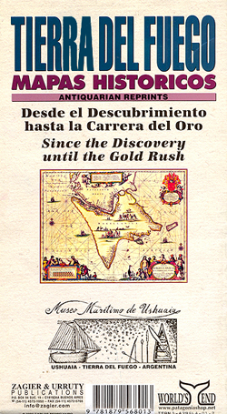
A collection of reproductions of historical maps of Tierra del Fuego, from 1559 to late 19th century. On one side is a reproduction of a map based on a British Admiralty chart used between 1886and 1891 by Julius Popper. On the reverse is a selection of nine smaller reproductions covering earlier cartographic history of Tierra del Fuego, starting from the times of the exploratory voyage of Magellan in the 16th century. Explanatory text – in Spanish and English – summarizes the history of Spanish, English and Dutch explorations in the region.

Related Products:
 Tierra del Fuego de Dios Map-Guide SPANISH
 Patagonia And Tierra Del Fuego Nautical Guide – 3rd Edition
 Tierra del Fuego and Isla Navarino
 Antarctica – Tierra del Fuego ITMB
 Tierra del Fuego – Sector Argentino
 Patagonia & Tierra del Fuego ITMB
 Tierra del Fuego – Cordillera Darwin – Lago Fagnano – Isla Navarino SIG Patagon
 Argentina South & Tierra del Fuego ITMB
 Tierra del Fuego – Antarctica
 Southern Patagonia – Tierra del Fuego
 The Lost Tribes of Tierra del Fuego: Selknam, Yamana, Kawesqar
 Antarctica Historical Map
 Admiralty Chart 1373 – South-Eastern Part of Tierra del Fuego
 Cape Horn to Cabo Penas Historical Map
 Old Folding Maps Reproductions of Historical Maps
 Colour Your Own Historical Maps
 Atlas: A World of Maps from the British Library
 Argentina: Zagier & Urruty Regional Touring Maps
 Great Britain: Cassini Historical Reproductions of Ordnance Survey One-Inch Maps of England & Wales
 Maps: Their Untold Stories
 Victorian Maps of England: The county and city maps of Thomas Moule
 Historical Maps of Alnwick & Alnmouth – from Earliest Times to 1918
 Palgrave Concise Historical Atlas of Eastern Europe
 A 16th Century Galleon – Spectacular Visual Guides
 Stanford`s Folio Smaller Railway Map of the United States (1876) – A2 Wall Map, Paper – Print on Demand
 Old Folding Maps Reproductions of Letts 1884 English County Maps
Stanford`s Folio Smaller Railway Map of the United States (1876) – A2 Wall Map, Canvas – Print on Demand
A History of the 20th Century in 100 Maps
Stanford`s Folio Smaller Railway Map of the United States (1876) – A3 Wall Map, Paper – Print on Demand
Old Folding Maps Reproductions of Letts 1884 English County Maps
Stanford`s Folio Smaller Railway Map of the United States (1876) – A2 Wall Map, Canvas – Print on Demand
A History of the 20th Century in 100 Maps
Stanford`s Folio Smaller Railway Map of the United States (1876) – A3 Wall Map, Paper – Print on Demand
 Ushuaia to Antarctica – Drake Passage – Polar Voyage Log Map
 An Historical Map of Coventry – from Medieval to Industrial City
 Maps That Changed the World
Stanford`s Folio Smaller Railway Map of the United States (1876) – A3 Wall Map, Canvas
Stanford`s Folio Smaller Railway Map of the United States (1876) – A1 Wall Map, Canvas
Maps That Changed the World
Stanford`s Folio Smaller Railway Map of the United States (1876) – A3 Wall Map, Canvas
Stanford`s Folio Smaller Railway Map of the United States (1876) – A1 Wall Map, Canvas
 Great Britain: Cassini Past and Present Historical Series
 Chile: SIG Patagon Exploration and Trekking Maps
 Tasiilak Historical Map
 Great Britain: Godfrey Editions of Historical Ordnance Survey Inch to a Mile Maps of England & Wales
Nuuk – Godthรฅb Historical Map
Great Britain: Godfrey Editions of Historical Ordnance Survey Inch to a Mile Maps of England & Wales
Nuuk – Godthรฅb Historical Map