Disclosure : This site contains affiliate links to products. We may receive a commission for purchases made through these links.
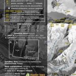
Tian Shan: Karakol – Engilchek Glacier – Jengish Chokusu (Pik Pobedy) – Khan Tengri Goskartografiya Trekking Map
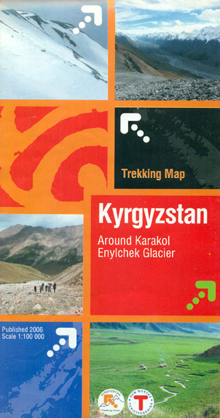
The easternmost part of Kyrgyzstan, between Lake Issyk-Kul and the Engilchek Glacier, on a contoured and GPS compatible, double-sided topographic map at 1:100,000 from Goskartografiya in Bishkek, with most place names in the Latin alphabet and an English map legend. Coverage extends eastwards from Kyzyl-Suu, the easternmost part of Lake Issyk-Kul and Karakol to the Engilchek Glacier with the peaks of Jengish Chokusu (Pik Pobedy) and Khan Tengri.The map has contours at 40m intervals with numerous spot heights, plus colouring for forests, moraine and glaciers. Road network indicates paved, gravel and dirt roads. An overprint highlights trekking routes. Most place names, of both towns/settlements and of topographic features, have been transliterated into Latin alphabet. The map has a 2-km UTM grid. Map legend is in English.PLEASE NOTE: deliveries of titles published in Kyrgyzstan are infrequent – no delivery time can be specified for any titles currently out of stock.

Related Products:
 Tien Shan: Lake Issyk-Kul North 100K Goskartografiya Trekking Map
 Tien Shan: Lake Issyk-Kul North Trekking Map
 Tian Shan – Khan Tengri – Pobeda Peak – Lenin Peak terraQuest Trekking Map
 Tien Shan: Bishkek & Kyrgyz Range – Kรผngรถy Ala-Too Range 100K Gostartografiya Trekking Map
 Khan Tengri – Tien Shan Alpenverein 0/15
 Batura Glacier
 Internal Tien-Shan Trekking Map
Karakol
Internal Tien-Shan Trekking Map
Karakol
 Iceland West: Akranes – Eirรญksjรถkull Glacier
 Inylchek – Tien Shan Alpenverein 0/14
 Many Glacier – Glacier and Waterton Lakes National Parks MT
 Georgia: Geoland 50K Trekking Maps
 SHOM Chart 7592 – Du glacier Dibble au glacier Mertz
 K2 and Baltoro Glacier Wall Map
 K2 and Baltoro Glacier
 Karakol & Jyrgalan Gostartografiya Trekking Map
 Kyrgyzstan & Tajikistan ITMB
 Sredna Gora
 Kyrgyzstan Gizi Map
 Kyrgyzstan Wall Map
 Crete: Lasithi Prefecture 150K Terrain Editions Map
 Vlasina Lake
 Northern Agrafa – Plastira Lake Anavasi 4.1
 Mt Kyllinin / Ziria Anavasi 8.31
 Crete Reise Know-How
 Lonely Planet Banff, Jasper and Glacier National Parks
 Iceland South East: Southern Vatnajรถkull
 Iceland North East: Hรบsavik – Lake Mรฝvatn – Bakkagerรฐi
 North Fork – Glacier National Park MT NGS Trails Illustrated Map 313
 Serbia North F&B
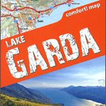 Lake Garda terraQuest Trekking Map
 Bulgaria (with Street Plans of Black Sea Resorts)
 Iceland North: Hvammstangi – Mรฝvatn Lake
 Serbia South F&B
 Lake Como terraQuest Trekking Map
 Central Asia Nelles
 Central Macedonia Terrain Editions Regional Map 2
 Bulgaria – City Centres Domino Road Map
 Strandzha Mountains: Burgas to the Turkish Border Domino Map