Disclosure : This site contains affiliate links to products. We may receive a commission for purchases made through these links.
Through The Eyes of the Vikings
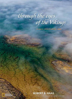
In 2005, aerial photographer and author Robert Haas introduced his first National Geographic title, “Through the Eyes of the Gods: An Aerial Vision of Africa”. Two years later came the popular “Through the Eyes of the Condor: An Aerial Vision of Latin America”. When Haas undertook his third high-flying project, he set out to conduct extensive aerial photography in the lands of the Vikings – concentrating on regions that transect the Arctic Circle, specifically Alaska, northern Canada, Greenland, Iceland, Norway, Sweden, and Finland. While photographing these lands over a three-year period, Haas endeavoured to capture imagery reflecting three key visual elements of the region: landscapes, wildlife, and human footprint. As the resulting body of work makes abundantly clear, the shots that Haas brought back reveal a much deeper and more complex picture than anyone expected. In portraying the far north, “Through the Eyes of the Vikings: An Aerial Vision of Arctic Lands” goes far beyond simply attractive pictures.Rather, this unusual book tells a combined visual and textual story about an endangered region whose unexpected beauty is worth preserving for its own sake – and whose precarious fate will impact the entire globe. Several narrative features add context to the visuals. Haas contributes a thoughtful introduction, and essays in each chapter quote from the works of noted Arctic authors and explorers, both historical and contemporary. These messages span 100 years of human interaction with the northlands and reflect on topics that range from the risks inherent in Arctic exploration to the appealing simplicity of native life to the current challenges posed by climate change. To help readers navigate the lands of the Vikings, National Geographic`s hallmark maps appear in full colour and detail. In addition to a large two-page map of the Arctic at the front of the book, the back matter features several pages of country maps, complete with notes on history, culture, topography, and environment, as well as facts on population, area, industries, and more.”Through the Eyes of the Vikings” reveals, in an unforgettable way, the visual magnificence and unique characteristics of each Arctic region – and it delivers a potent message of environmental urgency that cannot be ignored.

Related Products:
 The Age of the Vikings
 Vikings
 The Vikings in Britain and Ireland
 Vikings in the Supermarket
 The Vikings
 The Story Of The Vikings Sticker Bo
 The Wolf Age: The Vikings, the Anglo-Saxons and the Battle for the North Sea Empire
 Asterix and the Vikings
 Vikings: Life and legend
 Vikings Sticker Book
 River Kings: The Vikings from Scandinavia to the Silk Roads
 A Brief History of the Vikings
 The Oxford Illustrated History of The Vikings
 Modern Day Vikings – A Practical Guide to the Swedes
 The Children of Ash and Elm: A History of the Vikings
 National Geographic Rarely Seen: Photographs of the Extraordinary
 River Kings: A New History of Vikings from Scandinavia to the Silk Roads
 Ladybird Histories: Vikings
 From Above: The Story of Aerial Photography
 Cat Eyes and Dog Whistles: The Seven Senses of Humans and Other Animals
 Feast Your Eyes on Food
 Journeys with Open Eyes: Seeking Empathy with Strangers
 If I Close My Eyes Now
 National Geographic Visual Atlas Of The World, 2nd Edition: Fully Revised and Updated
 Dotter of Her Father`s Eyes
 The Dublin Art Book: The City Through the Eyes of its Artists
 Discovering the Vikings
 Amsterdam Canals: Through the Eyes of Cris Toala Olivares
 Into the Eyes of Lions
 Galapagos – Through Writers` Eyes
 National Geographic Arctic Regions – Published 1925 508 x 475 mm
 Topsy and Tim: Have Their Eyes Tested
 National Geographic Kids World Atlas, 5th Edition
 The Skies Above My Eyes
 Spotlights Vikings
 The Penguin Book of Norse Myths: Gods of the Vikings
 National Geographic Lands of the Bible 1967 Map – Published 2012 983 x 689 mm
 Open My Eyes, That I May See Marvellous Things
 National Geographic Atlas of the World Eleventh Edition
 Samurai Revolution: The Dawn of Modern Japan Seen Through the Eyes of the Shogun`s Last Samurai