Disclosure : This site contains affiliate links to products. We may receive a commission for purchases made through these links.
The North West Trail Cycle Route
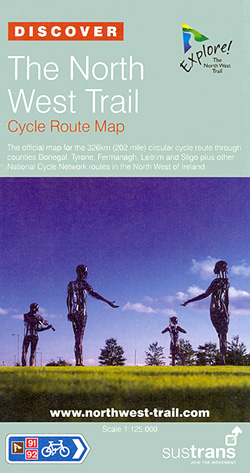
The North West Trail Cycle Route at 1:125,000 in a series of cycling maps from Sustrans, the charity behind developing UK’s National Cycle Network. The map is printed on light waterproof synthetic paper and presents several routes in the western part of Northern Ireland, taking in Strabane, Omagh, Enniskillen and the Upper and Lower Lough Erne. The routes also cross over to Donegal and Sligo in the Irish Republic Each title in the Sustrans series of cycling maps covers either a single route, presented in sections on separate strip maps, or a wider area with the main cycling route(s) prominently highlighted but other recommendations for cyclists also marked. The area covered each map is shown on our website on its individual ‘coverage” image.The route has markers indicating steep gradients, controlled access, distances and possible danger points. Route profiles indicate riding surface and the density of traffic (main road, minor road and traffic-free) and, where appropriate, street plans show the course of the route across towns and cities. On maps covering a wider area around the main National Cycle Route suggestions of possible day ride excursions are also marked. A range of symbols highlight various facilities and places of interest, including tourist information centres, youth hostels, cafes and pubs, grocery shops, cycle shops and hire, historical and natural sites, etc.For access by rail, the rail network is shown with stations and, where appropriate, metro stations are also marked. Topography is shows by altitude colouring. Unless specifically indicated in the individual description, the maps do not show British National Grid lines for GPS. Each title also contains contact addresses for various useful organizations, etc. Many titles are printed on light, waterproof and tear-resistant synthetic paper.

Related Products:
 Lรดn Las Cymru Cycle Route North: Holyhead – Llanidloes
 Coast & Castles Cycle Route North: Edinburgh – Aberdeen
 Sea to Sea Cycle Route: Whitehaven/Workington – Newcastle/Sunderland
 Strangford Lough Cycle Trail
 The Salmon Run – Dundee to Pitlochry Cycle Route
 Lรดn Cambria & Lรดn Teifi: Mid-Wales Cycle Routes
 Tour de Manche Vol. 1: North-West Normandy – Channel Is. – South Dorset Cycle Route (505km)
 Kattegattleden Cycle Route
 The Ultimate UK Cycle Route Planner
 North Wales – Lon Eifion – Lon Las Cefni – North Wales Coast Route Sustrans Cycle Map 24
 John O`Groats & North Scottish Coast Cycle Map
 Bath to Bournemouth Sustrans Cycle Route Map
 North Cumbria & Dumfries 110K Sustrans Cycle Map No. 35
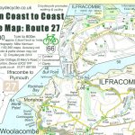 Devon Coast to Coast – Route 27 Cycle Map 66
 Braunton & Ilfracombe Cycle Map 60 – with Tarka Trail & Barnstaple
 North Northumberland & Scottish Borders Sustrans Cycle Map 39
 London – Land`s End Cycle Route: Beautiful Cycling Across Southern England
County Durham & North Yorkshire Sustrans Cycle Map 32
London – Land`s End Cycle Route: Beautiful Cycling Across Southern England
County Durham & North Yorkshire Sustrans Cycle Map 32
 West Dumfries & Galloway 110K Sustrans Cycle Map No. 36
 Cycling Northern France: Cycle Routes North of the Loire
 Lochs & Glens North Cycle Route
 Rhine Cycle Route 3 – Basel – Speyer Publicpress Cycle Touring 368
 Dundee, Angus & North Fife 110K Sustrans Cycle Map No. 44
 Danube-Lake Constance Cycle Route – Upper Swabia-Allgรคu Cycle Route Bikeline Map-Guide
 Green Route Cycle Trail: Dรผren – Aachen – Dutch Limburg – Beringen in Flanders (360km) Bikeline Map/Guide
 South West Wales 110K Sustrans Cycle Map No. 13
 Suffolk – Ipswich – Bury St Edmunds – Felixstowe – Suffolk Coast Cycle Route Sustrans Cycle Map 18
Egertal Cycle Route – Ohre Cycle Route Bikeline Map-Guide Compact
Suffolk – Ipswich – Bury St Edmunds – Felixstowe – Suffolk Coast Cycle Route Sustrans Cycle Map 18
Egertal Cycle Route – Ohre Cycle Route Bikeline Map-Guide Compact
 The C2C Cycle Route – Footprint Map-Guide to the 138 mile Sea to Sea Cycle Route
Rhine Cycle Route 4 – Speyer – Cologne Publicpress Cycle Touring 333
The C2C Cycle Route – Footprint Map-Guide to the 138 mile Sea to Sea Cycle Route
Rhine Cycle Route 4 – Speyer – Cologne Publicpress Cycle Touring 333
 Sandstone Way Cycle Route: Berwick-upon-Tweed – Hexham
Rhine Cycle Route 2 – Lake Constance – Basel Publicpress Cycle Touring 302
Sandstone Way Cycle Route: Berwick-upon-Tweed – Hexham
Rhine Cycle Route 2 – Lake Constance – Basel Publicpress Cycle Touring 302
 Lรดn Las Cymru North Sustrans Cycle Route Map
 Iller Cycle Route – Zusam Cycle Route Bikeline Map-Guide
 Way of the roses: The official guide to the national cycle network coast to coast cycle route from Morecambe to Bridlington
West Highland Way Harvey National Trail XT40
Way of the roses: The official guide to the national cycle network coast to coast cycle route from Morecambe to Bridlington
West Highland Way Harvey National Trail XT40
 Herefordshire, Worcestershire & North Gloucestershire 110K Sustrans Cycle Map No. 15
 South Cambridgeshire, Bedfordshire & North Hertfordshire 110K Sustrans Cycle Map No. 17
 South East Wales – Taff Trail – Celtic Trail – Lon Las Cymru – 3 Parks Trail Sustrans Cycle Map 12