Disclosure : This site contains affiliate links to products. We may receive a commission for purchases made through these links.
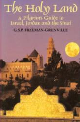
The Holy Land: A Pilgrim`s Guide to Israel and Jordan

Related Products:
 A Pilgrim`s Guide to The Holy Land: Israel and Jordan
 Holy Land – Israel – Palestine F&B Top 10 Tips
 Israel National Trail: Hike the land of Israel
 Holy Fire !: Travels in the Holy Land
 Holy Land NGS Wall Map
 Holy Land, Unholy War
 Jerusalem & Holy Land ITMB
 The Wall Between Us: Notes from the Holy Land
 Palestine or the Holy Land c.1818 SMALL
Palestine or the Holy Land c.1818 MEDIUM
Palestine or the Holy Land c.1818 SMALL
Palestine or the Holy Land c.1818 MEDIUM
 My Promised Land: the triumph and tragedy of Israel
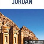
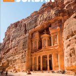 The Rough Guide to Jordan (Travel Guide with Free eBook)
 Jordan Globetrotter Travel Guide
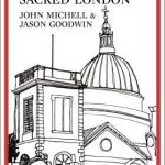 Pilgrim`s Guide To Sacred London, A
 Pilgrim Guide ‘“ Camino del Sureste
 Israel Bradt Guide
 A Pilgrim`s Guide to Oberammergau: and Its Passion Play
 Berlitz Pocket Guide Israel
 A Pilgrim`s Guide to Rome and Assisi: With Other Italian Shrines
 DK Eyewitness Travel Guide Jerusalem, Israel and the Palestinian Territories
 Insight Guides Pocket Israel (Travel Guide with Free eBook)
 A Pilgrim`s Guide to the Camino Ingles & Camino Finisterre: Including MuXia Circuit
 Hotspots Israel: A Travel Guide with a Difference
 Britain`s Pilgrim Places: The First Complete Guide to Every Spiritual Treasure
 A Pilgrim`s Guide to the Camino De Santiago: St. Jean – Roncevalles – Santiago
 Kamchatka – A Journal and Guide to Russia`s Land of Ice and Fire
 A Pilgrim`s Guide to the Camino De Santiago: Camino Frances St. Jean – Roncevalles – Santiago
 Svalbard (Spitsbergen), Franz Josef Land and Jan Mayen Bradt Guide
 Cool Japan Guide: Fun in the Land of Manga, Lucky Cats and Ramen
 A Pilgrim`s Guide to the Camino Sanabres & Camino Invierno: Ourense – a Laxe – Santiago Ponferrada – a Laxe – Santiago
 Ancient Jordan from the Air
 A Pilgrim`s Guide to the Camino Portugues: Lisbon – Porto – Santiago / Camino Central, Camino de la Costa, Variente Espiritual & Senda Litoral
 A Guide to Modernism in Metro-Land
 Lonely Planet Jordan
 Insight Guides Jordan
 The Lie of the Land – An Under the Field Guide to the British Isles
 Paderborn Land Route Bikeline Map-Guide Compact
 Jordan: Petra – Wadi Rum – Dead Sea Footprint Handbook
 The Adventurer`s Guide to Britain: 150 incredible experiences on land and water
 Hidden Treasures of Ethiopia: A Guide to the Remote Churches of an Ancient Land