Disclosure : This site contains affiliate links to products. We may receive a commission for purchases made through these links.
The Caribbean Destination Map

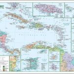
Caribbean Destination Map from the National Geographic presenting the region at 1:2,000,000 spread over both sides of a waterproof and tear-resistant sheet, with street plans of selected towns, a list of national parks, descriptions of popular islands, etc.On one side are the Bahamas with a plan of central Nassau, Cuba with a plan of Havana’s Old Town, Cayman Islands with a plan of George Town, Jamaica, and the Turks and Caicos Islands. Coverage also includes southern Florida and the coast of Mayan Riviera in Mexico, and a separate inset shows the main embarkation ports in USA for Caribbean cruises.On the reverse are the remaining islands: the Greater and the Lesser Antilles with Trinidad and Tobago and the coast of Venezuela. Street plans show Old San Juan on Puerto Rico and Charlotte Amalie in the US Virgin Islands.On the individual islands, as allowed by their size, the map shows the network of main roads and prominently highlights national parks and other protected areas which are also listed in a separate table for each side of the map. International airports are presented with their full names and domestic airports are also marked. Symbols indicate cruise ports, beaches and surfing or diving sites, casinos, etc. Both on the land and on the sea bed relief is shown by shading and altitude/depth colouring. The map includes brief descriptions of popular tourist destinations illustrated with colour photos, travellers tips and general tourist advice.

Related Products:
 Caribbean Cruises F&B
 Caribbean Islands Western Half ITMB Travel Atlas
 Caribbean – Lesser Antilles Nelles
 Caribbean Cruise Ports Marco Polo Pocket Guide – with pull out maps
 Caribbean Islands Explorer
 Caribbean Islands East & South ITMB Travel Atlas
 Caribbean Cruise Ports Of Call
 Caribbean Sea
 Caribbean Pilots Guide 2018
 Alaska`s Inside Passage NGS Destination Map
 Central America – Caribbean Islands – Mexico
 Berlitz Pocket Guide Caribbean Ports of Call
 SEMAR Chart 4 – Gulf of Mexico and Caribbean Sea
 Insight Guides Pocket Caribbean Ports of Call
 Caribbean NGS Classic Wall Map PAPER
 Caribbean NGS Classic Wall Map ENCAPSULATED
 Caribbean Marco Polo Map
 A Cruising Guide to the Northwest Caribbean
 Caribbean – Central America – Virgin Islands – Bahamas
 The Caribbean Traveler Guide
 Cayman Islands & Jamaica ITMB
 Virgin Islands Borch
 Cruise Ports Caribbean
 Arad – Timisoara Cartographia Street Plan
 Wildlife of the Caribbean
 Northland: Whangarei, Bay of Islands and 61 Provincial Towns Pathfinder
Curaรงao Dive Map/Guide
Northland: Whangarei, Bay of Islands and 61 Provincial Towns Pathfinder
Curaรงao Dive Map/Guide
 Chicago NGS City Destination Map
 Southeast Alaska and Inside Passage
 USA: National Geographic Destination Maps of Popular Scenic Regions
 Croatia F&B
Paris NGS City Destination Map
Croatia F&B
Paris NGS City Destination Map
 Caribbean Collins Wall Map
 Central America & the Caribbean – Stormrider Guide
 Caribbean: The Northern Islands
 Where to Watch Birds Central America & the Caribbean
 Miami & the Keys NGS City Destination Map
New Zealand ITMB
Miami & the Keys NGS City Destination Map
New Zealand ITMB
 California Marco Polo Map