Disclosure : This site contains affiliate links to products. We may receive a commission for purchases made through these links.
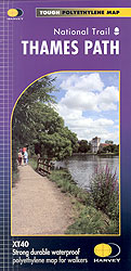
Thames Path Harvey National Trail XT40

The Thames Path National Trail map on light, waterproof and tear-resistant synthetic paper. Unlike other titles in Harvey’s very popular series covering the long-distance trails, The Thames Path map is at 1:60,000 and shows the whole route and the surrounding countryside on three large panels: on one side from the source to Dorchester in Oxfordshire, on the reverse the rest of the route on two panels.The overprint highlighting the route indicates whether it runs on a track, a path, a not visible path or a road, and within London indicates alternative routes on both sides of the river. Points where particular care should be taken crossing a road are clearly marked. Locations along the route and within easy distance from it are annotated with symbols indicating what facilities can be found there (campsites, caravan sites, youth hostels, pubs and refreshments, restaurants, shops and drinking water supplies, toilets, etc). On the river the maps shows locks where facilities are available, with a separate panel indicating what is available at each lock and providing phone numbers.In the surrounding countryside the map has contours at 10m intervals, with additional colouring for open forest/woodland and dense plantations. Roads a graded by colouring, local tracks and footpaths are marked, and railway lines are shown with stations. Within London Underground stations are shown (though not all are named); 18 of the capital’s major attractions are highlighted and listed with their websites. The map has British National Grid lines at intervals of 1km. Also provided are several other useful contact details, information on waymarking, general notes about the history of the Thames Paths, etc.To see other titles in this series please clock on the series link.


