Disclosure : This site contains affiliate links to products. We may receive a commission for purchases made through these links.
Tehran & Northern Iran ITMB
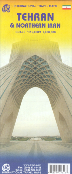
Tehran street plan at from ITMB with, on the reverse, a road map of northern Iran, both indexed. Also included are a diagram of the metro network and a road map of the environs of the capital. All place names are shown in Latin alphabet only.On one side is a street plan of Tehran showing names of neighbourhoods and most streets. Main traffic arteries across the city are highlighted and access onto expressway is very clearly presented. Metro stations are prominently marked and annotated with line numbers. A range of symbols shows various places of interest, services and facilities: selected hotels (with names), embassies, places of worship, shopping centres, cultural institutions, bus terminals, etc. The index lists main streets, squares and neighbourhoods. Also provided are a diagram of the metro lines and a road map of the city’s environs with access to the international airport.On the reverse is an indexed map of northern Iran showing road and rail connections as well as local airports. Main historical and archaeological sites are highlighted and some also annotated with brief descriptions. Topography is shown by altitude colouring with spot heights. The map also shows internal administrative boundaries with names of the provinces. Coverage extends north to Baku, west to Baghdad and Kirkuk, south to Kuwait City and, within Iran, to Shiraz (including Persepolis) and Zahedan, and east to the borders with Turkmenistan and Afghanistan. The map has latitude and longitude lines at intervals of 2ยบ.

Related Products:
 Iran & Tehran ITMB
 Moscow ITMB
 Iran F&B
 San Francisco & Northern California ITMB
 Sao Paulo & Brazil South Coast ITMB
 Kyoto & Japan West ITMB
 Osaka & Western Japan ITMB
 Delhi & Northern India ITMB
 Hungary & Budapest ITMB
 Helsinki & Southern Finland ITMB
 Taiwan & Taipei ITMB
 Singapore & Malay Peninsula ITMB
 Jakarta ITMB
 Santiago & Chile North ITMB
 Easter Island & Santiago ITMB
 Munich & Bavaria ITMB
 Czech Republic ITMB
 Manhattan & New York State ITMB
 Qatar and Doha City ITMB
 Marrakesh & Northern Morocco ITMB
 Barcelona & Catalonia ITMB
 Sydney & Australia East ITMB
 Bangkok & Thailand South ITMB
 Mumbai / Bombay – India West Coast ITMB
 Zurich & Switzerland NW ITMB
 Washington DC & Eastern Corridor (Boston to DC) ITMB
 Accra & Ghana South ITMB
 Oslo / Bergen & South of Norway ITMB
 Tokyo & Central Japan ITMB
 Brisbane & Queensland ITMB
Singapore Borch
Brisbane & Queensland ITMB
Singapore Borch
 Rome Borch
 Beijing & the Great Wall ITMB
Kabul & Historic Khyber Pass ITMB
Beijing & the Great Wall ITMB
Kabul & Historic Khyber Pass ITMB
 San Diego & USA South West Border ITMB
 Istanbul & Northwest Turkey ITMB
 Rome & Southern Italy ITMB
 Jasper National Park & Northern Alberta ITMB
 Bangkok Borch