Disclosure : This site contains affiliate links to products. We may receive a commission for purchases made through these links.
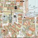
Tbilisi and Environs Geoland Street Plan
Tbilisi on a double-sided map (paper edition) from the locally based Geoland, with on one side a street plan of the city centre at 1:10,000 annotated with tourist accommodation, sights, etc, and on the reverse the environs at 1:50,000 on a detailed contoured road map.The street plan is annotated with a very wide range of symbols highlighting hotels, restaurants and cafes, shops and banks, cultural and educational establishments, sport and recreational facilities, embassies, etc. On the reverse is a topographic map with contours, relief shading, spot heights and colouring for different types of vegetation/land use such as orchards, vineyards, etc. The map shows the area’s road and rail networks and highlights various places of interest. UTM grid is drawn at 2km intervals, with margin ticks for latitude and longitude at 1’. All place names are in Latin alphabet only. Map legend is in English.

Related Products:
 Tbilisi and Environs Geoland Street Plan WATERPROOF
 Pafos Street Plan and District Road Map
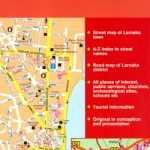 Larmaka Street Plan and District Road Map
 Bergen Cappelen Street Plan
 Chalkidiki / Halkidiki – Thessaloniki Street Plan Terrain Editions 412
 Salzburg F&B Tourist Street Plan
 Lithuania – Vilnius Street Plan
 Bishkek Street Plan
 Yalta Kartografija Street Plan
 Greater Oslo Cappelen Street Plan
 Linz F&B Tourist Street Plan
 Iasi Cartographia Street Plan
 Lugo and Environs CNIG Map
 Bamberg in 3-D Street Plan
 Limassol Pocket Street Plan
 Larnaka Pocket Street Plan
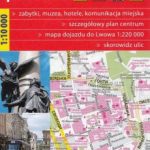 Lviv ExpressMap Street Plan
 Stuttgart in 3-D Street Plan
 Trier in 3-D Street Plan
 Salzburg F&B Street Plan
 Aachen in 3-D Street Plan
 Hanover in 3-D Street Plan
 Tallinn Jana Seta Street Plan WATERPROOF
 Jurmala Jana Seta Street Plan
 Munich in 3-D Street Plan
 Lรผbeck in 3-D Street Plan
 Dusseldorf in 3-D Street Plan
 Rothenburg ob der Tauber in 3-D Street Plan
 Lviv Kartografija Street Plan
 Barcelona: Modernisme Architecture Street Plan
 Cologne in 3-D Street Plan
 Kharkov Kartografija Street Plan
 Nuremberg Falk EXTRA Street Plan
 Kaliningrad Street Plan
 Hamburg in 3-D Street Plan
 Nuremburg in 3-D Street Plan
 Vilnius Jana Seta Pocket Street Plan
 Barcelona: Gaudรญ Architecture Street Plan
 Tbilisi Architecture Map
 Sikkim & India Northeast ITMB