Disclosure : This site contains affiliate links to products. We may receive a commission for purchases made through these links.
Talkot
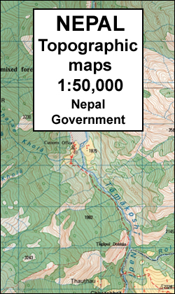
Talkot, sheet no. 2981-06, in the topographic survey of Nepal at 1:50,000 published by the Nepali Government in the late 1990s and early 2000s and produced from remote sensing data by Finnish cartographers as part of that country’s international aid program. The maps cover 15’ x 15’ quadrangles.IMPORTANT ‘“ PLEASE NOTE BEFORE ORDERING: AVAILABILITY: although, theoretically at least, still in print, these maps are very difficult to get locally in Nepal and/or from various suppliers elsewhere specializing in obtaining such maps. DELIVERIES MAY TAKE SEVERAL WEEKS OR EVEN MONTHS.PROBLEMS WITH PLACE NAMES: reports from previous users indicate that transliteration of place names differs from that used widely not only on other maps and in guide books but also on the ground itself, in road signs and in the tourist and trekking industry in general. Whilst most names are similar enough to be easily recognizable, e.g. Namche Bajar for Namche Bazar or Lantan for Langtang, we have been told of confusion and difficulties arising from different spellings appearing on these maps.TREKKING ROUTES AND TOURIST INFORMATION: whilst the maps show foot trails and mark locations of temples, etc, they carry no specific trekking information. Major trekking routes and places of interest are not highlighted. There is no marking for base camps and other tourist facilities.Map specifications:Contours are at 40m intervals, with graphics and/or coloring to show various features of the terrain (glaciers with moraines and crevasses, quarries, gravel or clay pits, etc.) and vegetation (forests, bush, grass, orchards and plantations, etc). Additional comments such as ‘open mixed forest mainly bajh and pine” annotate many area. The maps have numerous spot heights, but relatively few peaks are named. Areas outside the country’s borders are left blank.Settlements in remote areas are indicated by markings for individual buildings and the placing of names does not always make it clear which group of buildings they refer to. Road network distinguishes between major and minor foot trails. Symbols mark features such as temples, schools and hospitals, police stations, etc. Also shown are the country’s administrative divisions. The maps have a 1-km UTM grid, plus latitude and longitude lines at intervals of 5’. Map legend and all the text is in English.Coverage: the whole country is now covered, with the north at 1:50,000, plus central and southern Nepal at 1:25,000. The two series are complementary, do not overlap and use the same grid and numbering system (apart from the Lumbini Zone, where a different grid and numbering are used). For areas not shown on our grid and titles not listed here, please contact us by e-mail, but please do bear in mind the problems with availability and the likely very long delivery time.


