Disclosure : This site contains affiliate links to products. We may receive a commission for purchases made through these links.
Switzerland K+F Administrative Map
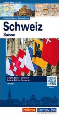
A very large sheet with an attractive and informative combination of two maps: administrative and postcode. On one side is an administrative map of the country, with a road map as its base. The map has plenty of geographical information: names of valleys, rivers, lakes, and glaciers, plus spot heights for numerous peaks. Each canton is shown in a different colour and subdivided into districts. Around the map are information panels giving essential facts about each canton: date of joining the Swiss Confederation, area, population, population density, number of districts and communes, and the highest and lowest points. A separate booklet attached to the cover provides an index which also includes lists of mountains, rives, lakes, mountain passes, etc.On the reverse side is a postcode map of Switzerland, with its base map showing both roads and the full rail network, including mountain railways, cable car lines, and chair lifts. Names of all towns and villages are annotated with their post codes, and are also listed in an index placed around the map. Map legends are in French, German, Italian and Romansh only.

Related Products:
 Switzerland K+F Postcode Wall Map
 Switzerland Castles Map – East
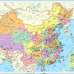
 The People`s Republic of China Administrative Map
 Germany Administrative F&B Wall Map
 Switzerland Borch
 China Administrative Wall Map
 Switzerland, My Holiday Map
 Switzerland Castles Map – West Swisstopo 9801
 Austria F&B Administrative Map
 Switzerland Hallwag Touring Atlas
 Switzerland Hallwag New Travel Map
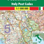 Italy Postcode Freytag & Berndt Wall Map
 Switzerland K+F Activity Map
Switzerland Hallwag Motorcycle Map Set
Switzerland K+F Activity Map
Switzerland Hallwag Motorcycle Map Set
 Switzerland K+F Cycling Map
Switzerland ACS Road Map 2022
Switzerland K+F Cycling Map
Switzerland ACS Road Map 2022
 Postcode Atlas of Britain and Northern Ireland
 Switzerland Swisstopo National Map
 Museum Map of Switzerland
 Valais, Switzerland – An Undiscovered Swiss Canton
 Switzerland 500K Swisstopo 0070
 Zurich & Switzerland NW ITMB
Switzerland ACS Road Map 2021
Zurich & Switzerland NW ITMB
Switzerland ACS Road Map 2021
 Switzerland 200K DOUBLE-SIDED
 Switzerland 3in1 Flash Guide
 Switzerland High 5 Edition Road Map
 France Administrative Departments Michelin
 China Administrative Gizi Map
Geological Map of Switzerland
China Administrative Gizi Map
Geological Map of Switzerland
 Switzerland: Michelin 200K Road Maps
 China Gizi Map Administrative Wall Map
 Switzerland Hallwag City Atlas
 Switzerland Romandy Hallwad Road Map
 Switzerland K+F Public Transport Map
 Lausanne Switzerland
 Switzerland Marco Polo Road Map
 France IGN Administrative Wall Map
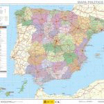 Spain CNIG Administrative Wall Map
 Switzerland: Ice & Glaciers Once and Today Swisstopo Map No. 306
 Kiev Administrative Region