Disclosure : This site contains affiliate links to products. We may receive a commission for purchases made through these links.
Sweden Marco Polo Map
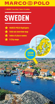
Sweden at 1:800,000 on a large, double-sided road map from Marco Polo Travel Publishing with prominent highlighting of interesting locations, enlargements for the environs of Stockholm and Gothenburg, plus an index booklet with 5 city maps and brief descriptions of 15 selected top sights, etc. Sweden is divided between the two sides of the map with a generous overlap and coverage includes the whole of Norway and Denmark, extending south to Hamburg and the Baltic coast of Germany.Cartography is from the renowned German publishers MairDumont. Road network includes minor roads, highlights scenic roads and special tourist routes, shows intermediate driving distances on main roads, and indicates motorway services, toll stations, caravan and vehicle restrictions, seasonal closures of mountain roads, etc. Railway lines and local airports are included, as well as administrative divisions with names of the provinces. Locations of interest are highlighted, with separate colouring for towns or villages and for natural sites; 15 most interesting sights are cross-referenced to their descriptions in a booklet attached to the map cover. Symbols show locations of campsites, youth hostels, etc. National parks and other protected areas are marked and topography is presented by relief shading with plenty of names of mountain ranges, valleys, etc. Latitude and longitude lines are drawn at 1ยบ intervals. The index is in the booklet. Enlargements show in greater detail the environs of Stockholm and Gothenburg and the booklet also provides street plans of town centres in these two cities plus in Malmรถ, Helsingborg and Uppsala, plus lists of airports, UNESCO World Heritage sites, and amusement parks. Multilingual map legend and all the text include English.A fold-out flap in the cover shows for route planning an overview of the whole area covered by the map plus the adjacent regions, prominently highlighting main places of interest, with the grid reference system in the margins making it easier to find locations on the main map. Also included are a distance/driving times table and basic driving regulations.

Related Products:
 Romania Marco Polo Map
 Ireland Marco Polo Map
 Portugal Marco Polo Map
 Belgium – Luxembourg Marco Polo Map
 Netherlands Marco Polo Map
 France Marco Polo Map
 Germany North Marco Polo Zoom Map
 Germany South Marco Polo Zoom Map
 Italy Marco Polo Map
 California Marco Polo Map
 USA West Marco Polo Map
 Spain – Portugal Marco Polo Map
 Europe Marco Polo Map
 USA East Marco Polo Map
 Thailand – Vietnam – Myanmar / Burma – Cambodia – Laos Marco Polo Map
 Germany: Marco Polo 200K Regional Road Maps
 Saxony Marco Polo Regional Map 9
 Denmark Marco Polo Map
 Finland & Sweden ITMB
 South Africa – Namibia – Botswana Marco Polo Map
 Canada Marco Polo Map
 Schleswig-Holstein – Hamburg – Bremen Marco Polo Regional Map 1
 Thuringia Marco Polo Regional Map 7
 Hesse Marco Polo Regional Map 6
 Saxony-Anhalt Marco Polo Regional Map 8
 Mecklenburg-Vorpommern Marco Polo Regional Map 2
 North Rhine-Westphalia Marco Polo Regional Map 5
 Cyprus Marco Polo Map
 Cuba Marco Polo Map
 Berlin – Brandenburg Marco Polo Regional Map 4
 Lower Saxony – Bremen – Hamburg Marco Polo Regional Map 3
 Bavaria North Marco Polo Regional Map 12
 Kenya Marco Polo Road Map
 Bavaria South Marco Polo Regional Map 13
 Baden-Wurttemberg Marco Polo Regional Map 11
 Rhineland-Palatinate – Saarland Marco Polo Regional Map 10
 Turkey Marco Polo Map