Disclosure : This site contains affiliate links to products. We may receive a commission for purchases made through these links.
Sumatra ITMB
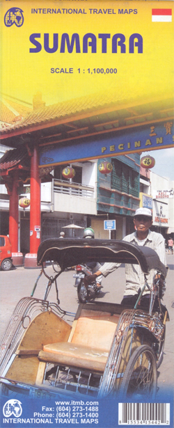
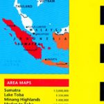
Sumatra at 1:1,100,000 on an indexed, double-sided map from ITMB, with coverage of the southern part of the Malaysian Peninsula with Kuala Lumpur, plus street plans of Medan, Padang and Palembang. Coverage includes the Riau and Linggga archipelagoes and most of Bangka, plus the islands west of Sumatra: Simeulue, Tuangku and the Banyak Archipelago, Nias, Batu, Tanahmasa, Tanahbala, Soberut, Sipora, North and South Pagai, and Enggand.The island’s topography is shown by altitude colouring with numerous spot heights (both in feet) and graphics showing swamp areas. National parks are highlighted. Road network includes minor roads and tracks. Railways and locations of local airfields are indicated, as well as internal boundaries and names of administrative units. Symbols highlight various places of interest, selected tourist accommodation, beaches, etc. The map has latitude and longitude grid at intervals of 1ยบ and a separate index of localities for each side.Large street plans annotated with sights and facilities including hotels and restaurants, etc. all with names, cover Medan, Padang and Palembang

Related Products:
 Sumatra – Medan Periplus Travel Map
 Sumatra Reise-Know-How Map
 Togo & Benin ITMB
 Mauritius & Reunion ITMB
 Oman & Yemen ITMB
 Borneo / Kalimantan ITMB
 Middle East ITMB Travel Atlas
 Guyana, Suriname & French Guiana ITMB
 Thailand ITMB
 Albania ITMB
 Kazakhstan & Uzbekistan ITMB
 Romania & Moldova ITMB
 Thailand, Vietnam, Laos & Cambodia ITMB Travel Atlas
 Myanmar / Burma ITMB
 Japan North & Hokkaido ITMB
 Cuba ITMB
 Tanzania ITMB
 China South ITMB
Borneo, Java, Sumatra, & the Philippine Islands c.1900
China South ITMB
Borneo, Java, Sumatra, & the Philippine Islands c.1900
 Quito & Central Ecuador ITMB
 South America ITMB Travel Atlas
 Algeria ITMB
 Ghana ITMB
 Mexico ITMB
 Senegal & Gambia ITMB
 Guatemala ITMB
 Hue – Da Nang & Vietnam Centra ITMB
 Southern Vietnam – Mekong Delta ITMB
 Singapore & Malay Peninsula ITMB
 Los Angeles & Southern California ITMB
 Kilimanjaro & Tanzania North ITMB
 Malaysia ITMB
Zambia & Eastern Africa ITMB Road Map
Malaysia ITMB
Zambia & Eastern Africa ITMB Road Map
 Paraguay – Bolivia South ITMB
 Guangzhou & China South ITMB
 Cayman Islands & Jamaica ITMB
 Japan South ITMB Railway & Road Map
 Morocco ITMB
 Qatar and Doha City ITMB