Disclosure : This site contains affiliate links to products. We may receive a commission for purchases made through these links.
Stratford 1867 – 42.1
Stratford in 1867 in a fascinating series of reproductions of old Ordnance Survey plans in the Alan Godfrey Editions, ideal for anyone interested in the history of their neighbourhood or family. Three versions of this map cover the same area, stretching from Hackney Cut Navigation and the River Lea eastward to Romford Road and Carnarvon Road, and from Temple Mills Lane and Chandos Road southward to Lett Road and Langthorne Street. The maps have a lot of railway information, including Stratford, Maryland and Stratford Market stations, and the GER Railway Works, sidings and loops north of the station; an essential map for students of the Great Eastern Railway. The town is also shown in detail, with the 1867 version especially attractive. Other features include tramways, Stratford New Town, Stratford Marsh, Broadway, Waterworks River, Town Hall. Many more buildings are shown by 1914 when roads include High Street, The Grove, Leytonstone Road, Vicarage Lane, and countless more. Each map also has short extracts from contemporary directories.About the Alan Godfrey Editions of the 25″ OS Series:Selected towns in Great Britain and Ireland are covered by maps showing the extent of urban development in the last decades of the 19th and early 20th century. The plans have been taken from the Ordnance Survey mapping and reprinted at about 15 inches to one mile (1:4,340). On the reverse most maps have historical notes and many also include extracts from contemporary directories. Most maps cover about one mile (1.6kms) north/south, one and a half miles (2.4kms) across; adjoining sheets can be combined to provide wider coverage.FOR MORE INFORMATION AND A COMPLETE LIST OF ALL AVAILABLE TITLES PLEASE CLICK ON THE SERIES LINK.

Related Products:
 Stratford 1914 – 42.3
 Bow, Bromley & West Ham 1867 – 53.1
 Poplar & Canning Town 1867 – 65.1
Chiswick 1867 – 85.1
Poplar & Canning Town 1867 – 65.1
Chiswick 1867 – 85.1
 West India Docks 1867 – 79.1
 Plumstead 1867
 Southfields & Wimbledon Park 1867 – 123.2
 Greenwich and the Isle of Dogs 1867
Leyton 1863-1867
Greenwich and the Isle of Dogs 1867
Leyton 1863-1867
 Lewisham 1863-67 – 119.1
Wisbech 1900
Lewisham 1863-67 – 119.1
Wisbech 1900
 Snaresbrook 1939
 North Shields and Chirton 1894
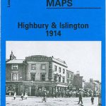 Highbury & Islington 1914 – 39.3
 Highbury & Islington 1894 – 39.2
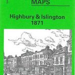 Highbury & Islington 1871 – 39.1
 Canning Town & Custom House 1894 – 66.2
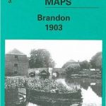 Brandon 1903
 Canning Town & Custom House 1914 – 66.3
Central Croydon 1895 – 14.10
Wanstead 1915 – 24.3
Hounslow West 1894 – 20.06a
Canning Town & Custom House 1914 – 66.3
Central Croydon 1895 – 14.10
Wanstead 1915 – 24.3
Hounslow West 1894 – 20.06a
 Cheetham & Higher Broughton 1915 – 104.02b
 Fleetwood 1910
 Walton on the Hill 1906
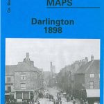 Darlington 1898 – 55.06a
 Sheffield Longley 1902
 Ilford 1938
 Kentish Town & Camden 1894 – 38.2
Hayle and Lelant 1876
Kentish Town & Camden 1913 – 38.3
Kentish Town & Camden 1894 – 38.2
Hayle and Lelant 1876
Kentish Town & Camden 1913 – 38.3
 Handsworth 1913
Bideford 1904 – 19.06
Handsworth 1913
Bideford 1904 – 19.06
 Upper Edmonton 1894 – 3a
 Knottingley 1905
Selly Oak and Bournville 1903
Knottingley 1905
Selly Oak and Bournville 1903
 Hunmanby 1926
Plymouth North 1893
Hunmanby 1926
Plymouth North 1893
 Putney & NW Wandsworth 1894 – 113.2
 Goole 1905